
By bicycle from Berkeley to Emeryville
Customize your own route based on our template or discover how our community prefers to cycle from Berkeley to Emeryville.
Route template
Berkeley to Emeryville
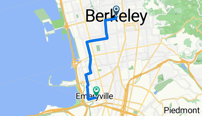
- 23 min
- Duration
- 6.9 km
- Distance
- 4 m
- Ascent
- 47 m
- Descent
- 18 km/h
- Avg. speed
- 52 m
- Max. altitude
This easygoing ride takes you from the vibrant college town of Berkeley down to the creative hub of Emeryville—a perfect route for anyone wanting a chill cycling experience. You’ll start near the UC Berkeley campus (go Bears!) and cruise mostly on quiet, paved roads, passing through tree-lined streets and eclectic neighborhoods.
There’s barely any uphill (just a tiny ascent at the start), and the route is mostly a gentle descent toward the bay. Expect a mix of smooth asphalt and stretches of concrete, with about a quarter of the route on dedicated cycleways—ideal for relaxed pedaling.
Emeryville, your destination, is known for its art spaces, shopping, and as home to Pixar Animation Studios—so don’t be surprised if it feels a little animated! At just under 7 km, this ride is the perfect way to connect two of the East Bay’s most interesting cities without breaking a sweat.
Community
Top users in this region


From our community
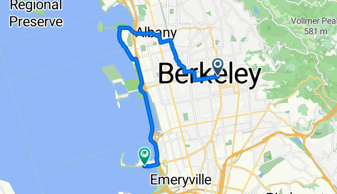
The best bike routes from Berkeley to Emeryville

college/bancroft <--> san pablo/alcatraz
Cycling route in Berkeley, California, United States
- 5.2 km
- Distance
- 4 m
- Ascent
- 88 m
- Descent

Centennial-El Toyonal-Lomas Cantadas
Cycling route in Berkeley, California, United States
- 34.1 km
- Distance
- 793 m
- Ascent
- 862 m
- Descent

Escape from Berkeley #1
Cycling route in Berkeley, California, United States
- 56 km
- Distance
- 925 m
- Ascent
- 1,011 m
- Descent


De Grant Street 2200, Berkeley à Potter Street 800, Berkeley
Cycling route in Berkeley, California, United States
- 3.4 km
- Distance
- 0 m
- Ascent
- 28 m
- Descent

Berkeley - Oakland Chinatown
Cycling route in Berkeley, California, United States
- 11.3 km
- Distance
- 8 m
- Ascent
- 34 m
- Descent

Ironworks
Cycling route in Berkeley, California, United States
- 4.5 km
- Distance
- 0 m
- Ascent
- 76 m
- Descent

1845–1849 University Ave, Berkeley to 874 58th St, Oakland
Cycling route in Berkeley, California, United States
- 54.8 km
- Distance
- 1,251 m
- Ascent
- 1,279 m
- Descent
home through Albany
Cycling route in Berkeley, California, United States
- 13.3 km
- Distance
- 61 m
- Ascent
- 118 m
- Descent

The REAL way home
Cycling route in Berkeley, California, United States
- 7.7 km
- Distance
- 28 m
- Ascent
- 84 m
- Descent

South Dr, Berkeley to 4150 Webster St, Oakland
Cycling route in Berkeley, California, United States
- 5.7 km
- Distance
- 15 m
- Ascent
- 76 m
- Descent

Miles Recording Studio from Home
Cycling route in Berkeley, California, United States
- 3 km
- Distance
- 0 m
- Ascent
- 44 m
- Descent
Discover more routes
 De Grant Street 2200, Berkeley à Potter Street 800, Berkeley
- Distance
- 3.4 km
- Ascent
- 0 m
- Descent
- 28 m
- Location
- Berkeley, California, United States
 Berkeley - Oakland Chinatown
- Distance
- 11.3 km
- Ascent
- 8 m
- Descent
- 34 m
- Location
- Berkeley, California, United States
 Ironworks
- Distance
- 4.5 km
- Ascent
- 0 m
- Descent
- 76 m
- Location
- Berkeley, California, United States
 1845–1849 University Ave, Berkeley to 874 58th St, Oakland
- Distance
- 54.8 km
- Ascent
- 1,251 m
- Descent
- 1,279 m
- Location
- Berkeley, California, United States
 home through Albany
- Distance
- 13.3 km
- Ascent
- 61 m
- Descent
- 118 m
- Location
- Berkeley, California, United States
 The REAL way home
- Distance
- 7.7 km
- Ascent
- 28 m
- Descent
- 84 m
- Location
- Berkeley, California, United States
 South Dr, Berkeley to 4150 Webster St, Oakland
- Distance
- 5.7 km
- Ascent
- 15 m
- Descent
- 76 m
- Location
- Berkeley, California, United States
 Miles Recording Studio from Home
- Distance
- 3 km
- Ascent
- 0 m
- Descent
- 44 m
- Location
- Berkeley, California, United States
Routes from Berkeley
By bicycle from
Berkeley to Piedmont
By bicycle from
Berkeley to Oakland