
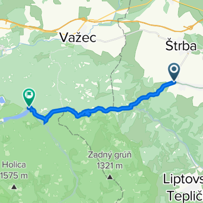
Route template
Strba to Hybe

- 2 h 26 min
- Duration
- 36.8 km
- Distance
- 950 m
- Ascent
- 1,120 m
- Descent
- 15.1 km/h
- Avg. speed
- 917 m
- Max. altitude
If you’re up for an adventure in the foothills of the High Tatras, this cycling route from Štrba to Hybe is a perfect pick. Starting in Štrba—a charming village known for its gateway to the High Tatras and proximity to the scenic Štrbské Pleso—you’ll roll through about 37 km of mixed surfaces. Expect a bit of everything: mostly asphalt, but there’s enough gravel and track to keep things interesting.
The route serves up a hearty 950 meters of climbing, but the descents are even longer, so get ready for some thrilling downhills. The journey winds you amidst mountain views, quiet roads, and wooded tracks, taking you through tranquil rural areas before you finish in Hybe. Hybe is a sleepy village with a rich mining history and traditional Slovak architecture, offering a perfect spot to wind down after your ride.
With long stretches of peaceful tracks and only brief moments on busier roads, you’ll have plenty of time to soak in the mountain air and maybe even spot some wildlife. Don’t forget your camera—and maybe some snacks for the ride!
Community
Top users in this region


From our community
The best bike routes from Strba to Hybe

štrba - horná nádrž el. čierny váh
Cycling route in Strba, Prešov Region, Slovakia
- 33.1 km
- Distance
- 647 m
- Ascent
- 354 m
- Descent

Štr,3,Tichá,ČS
Cycling route in Strba, Prešov Region, Slovakia
- 88.3 km
- Distance
- 1,175 m
- Ascent
- 1,415 m
- Descent

Štrba,Ticha,ČS
Cycling route in Strba, Prešov Region, Slovakia
- 88.2 km
- Distance
- 1,254 m
- Ascent
- 1,493 m
- Descent

Prechod 4 pohoriami - 2011
Cycling route in Strba, Prešov Region, Slovakia
- 25.3 km
- Distance
- 625 m
- Ascent
- 369 m
- Descent

Štrba Čierný Váh
Cycling route in Strba, Prešov Region, Slovakia
- 19.4 km
- Distance
- 472 m
- Ascent
- 213 m
- Descent

Teplická 251, Liptovská Teplička do Kráľova Lehota
Cycling route in Strba, Prešov Region, Slovakia
- 30 km
- Distance
- 819 m
- Ascent
- 1,063 m
- Descent

Štrba do Kráľova Lehota
Cycling route in Strba, Prešov Region, Slovakia
- 56.2 km
- Distance
- 757 m
- Ascent
- 1,000 m
- Descent

Strbske pleso - Vienna
Cycling route in Strba, Prešov Region, Slovakia
- 51.4 km
- Distance
- 413 m
- Ascent
- 1,012 m
- Descent

49.032° N 20.073° W to 49.016° N 19.936° W
Cycling route in Strba, Prešov Region, Slovakia
- 12.8 km
- Distance
- 244 m
- Ascent
- 372 m
- Descent

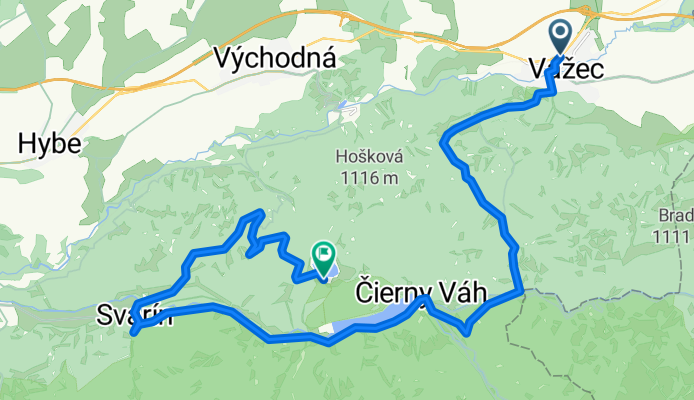
vazec Cierny Vah
Cycling route in Strba, Prešov Region, Slovakia
- 26.3 km
- Distance
- 737 m
- Ascent
- 380 m
- Descent

Discover more routes
 Štrba Čierný Váh
- Distance
- 19.4 km
- Ascent
- 472 m
- Descent
- 213 m
- Location
- Strba, Prešov Region, Slovakia
 Teplická 251, Liptovská Teplička do Kráľova Lehota
- Distance
- 30 km
- Ascent
- 819 m
- Descent
- 1,063 m
- Location
- Strba, Prešov Region, Slovakia
 Štrba do Kráľova Lehota
- Distance
- 56.2 km
- Ascent
- 757 m
- Descent
- 1,000 m
- Location
- Strba, Prešov Region, Slovakia
 Strbske pleso - Vienna
- Distance
- 51.4 km
- Ascent
- 413 m
- Descent
- 1,012 m
- Location
- Strba, Prešov Region, Slovakia
 49.032° N 20.073° W to 49.016° N 19.936° W
- Distance
- 12.8 km
- Ascent
- 244 m
- Descent
- 372 m
- Location
- Strba, Prešov Region, Slovakia
 ftgthfg
- Distance
- 18.5 km
- Ascent
- 487 m
- Descent
- 231 m
- Location
- Strba, Prešov Region, Slovakia
 vazec Cierny Vah
- Distance
- 26.3 km
- Ascent
- 737 m
- Descent
- 380 m
- Location
- Strba, Prešov Region, Slovakia
 dolná nádrž
- Distance
- 17.6 km
- Ascent
- 240 m
- Descent
- 367 m
- Location
- Strba, Prešov Region, Slovakia
Routes from Strba
Cycling day trip from
Strba to Poprad
Cycling day trip from
Strba to Vysoké Tatry