

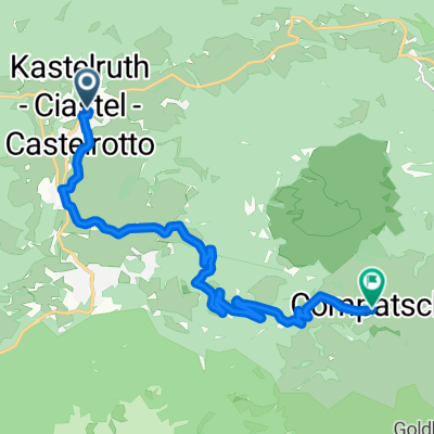
Kastelruth – Seiseralm – Pufels – Kastelruth
A cycling route starting in Kastelruth, Trentino-Alto Adige, Italy.
Overview
About this route
Es handelt sich dabei um die Route Nr. 24 aus dem Buch "E-Bike & Mountainbike Südtirol . Dolomiten . Gardasee" von Christjan Ladurner und Barbara. Verlag Tappeiner. Der Start- und zugleich auch -zielpunkt ist ein Parkplatz in der Nähe des Kreisverkehrs der Ortschaft Telfen / Lazin, südlich von Kastelruth!
- -:--
- Duration
- 25.9 km
- Distance
- 1,096 m
- Ascent
- 1,097 m
- Descent
- ---
- Avg. speed
- 1,871 m
- Max. altitude

Route quality
Waytypes & surfaces along the route
Waytypes
Road
12.2 km
(47 %)
Busy road
8.7 km
(34 %)
Surfaces
Paved
19.4 km
(75 %)
Unpaved
0.8 km
(3 %)
Asphalt
19.4 km
(75 %)
Pebblestone
0.5 km
(2 %)
Continue with Bikemap
Use, edit, or download this cycling route
You would like to ride Kastelruth – Seiseralm – Pufels – Kastelruth or customize it for your own trip? Here is what you can do with this Bikemap route:
Free features
- Save this route as favorite or in collections
- Copy & plan your own version of this route
- Sync your route with Garmin or Wahoo
Premium features
Free trial for 3 days, or one-time payment. More about Bikemap Premium.
- Navigate this route on iOS & Android
- Export a GPX / KML file of this route
- Create your custom printout (try it for free)
- Download this route for offline navigation
Discover more Premium features.
Get Bikemap PremiumFrom our community
Other popular routes starting in Kastelruth
 Giro2015 15.etape
- Distance
- 26.1 km
- Ascent
- 894 m
- Descent
- 895 m
- Location
- Kastelruth, Trentino-Alto Adige, Italy
 11.7. - Kastelruth - Weisslahnbad
- Distance
- 51.1 km
- Ascent
- 1,088 m
- Descent
- 1,089 m
- Location
- Kastelruth, Trentino-Alto Adige, Italy
 2016 Giro D'Italia Stage 15
- Distance
- 11.1 km
- Ascent
- 819 m
- Descent
- 29 m
- Location
- Kastelruth, Trentino-Alto Adige, Italy
 Ortisei Scigliar Castelrotto da fare al contrario
- Distance
- 51.3 km
- Ascent
- 1,434 m
- Descent
- 1,440 m
- Location
- Kastelruth, Trentino-Alto Adige, Italy
 Castelrotto-Cortina
- Distance
- 41 km
- Ascent
- 1,801 m
- Descent
- 1,255 m
- Location
- Kastelruth, Trentino-Alto Adige, Italy
 St.Oswald-Kastelruth-Seiser Alm-Seis-St.Oswald
- Distance
- 35.9 km
- Ascent
- 1,313 m
- Descent
- 1,281 m
- Location
- Kastelruth, Trentino-Alto Adige, Italy
 Telfen 58, Telfen-Lanzin do Telfen-Lanzin 59a, Castelrotto
- Distance
- 14 km
- Ascent
- 1 m
- Descent
- 77 m
- Location
- Kastelruth, Trentino-Alto Adige, Italy
 seiser alm
- Distance
- 22.2 km
- Ascent
- 774 m
- Descent
- 778 m
- Location
- Kastelruth, Trentino-Alto Adige, Italy
Open it in the app