
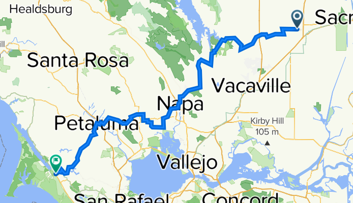
Davis > Point Reyes
A cycling route starting in Davis, California, United States.
Overview
About this route
This takes you through highways and byways from Davis to Point Reyes. There are some sketchy sections but overall the route works well.
- -:--
- Duration
- 155.7 km
- Distance
- 905 m
- Ascent
- 914 m
- Descent
- ---
- Avg. speed
- 327 m
- Max. altitude

Route quality
Waytypes & surfaces along the route
Waytypes
Busy road
65.4 km
(42 %)
Road
51.7 km
(33 %)
Surfaces
Paved
30.4 km
(20 %)
Paved (undefined)
19 km
(12 %)
Asphalt
11.4 km
(7 %)
Continue with Bikemap
Use, edit, or download this cycling route
You would like to ride Davis > Point Reyes or customize it for your own trip? Here is what you can do with this Bikemap route:
Free features
- Save this route as favorite or in collections
- Copy & plan your own version of this route
- Split it into stages to create a multi-day tour
- Sync your route with Garmin or Wahoo
Premium features
Free trial for 3 days, or one-time payment. More about Bikemap Premium.
- Navigate this route on iOS & Android
- Export a GPX / KML file of this route
- Create your custom printout (try it for free)
- Download this route for offline navigation
Discover more Premium features.
Get Bikemap PremiumFrom our community
Other popular routes starting in Davis
 Short And Sweet Afternoon Route In Davis
- Distance
- 2.9 km
- Ascent
- 12 m
- Descent
- 4 m
- Location
- Davis, California, United States
 Restful route in Sacramento
- Distance
- 14.5 km
- Ascent
- 19 m
- Descent
- 24 m
- Location
- Davis, California, United States
 Davis > Point Reyes
- Distance
- 155.7 km
- Ascent
- 905 m
- Descent
- 914 m
- Location
- Davis, California, United States
 davis bike loop #1
- Distance
- 6.9 km
- Ascent
- 19 m
- Descent
- 18 m
- Location
- Davis, California, United States
 Davis/Winters
- Distance
- 24.1 km
- Ascent
- 46 m
- Descent
- 22 m
- Location
- Davis, California, United States
 davis mtb/gravel
- Distance
- 47.7 km
- Ascent
- 23 m
- Descent
- 22 m
- Location
- Davis, California, United States
 300–328 3rd St, Davis to 2455 W Capitol Ave, West Sacramento
- Distance
- 19.2 km
- Ascent
- 3 m
- Descent
- 16 m
- Location
- Davis, California, United States
 601 Oeste Dr, Davis to 601 Oeste Dr, Davis
- Distance
- 49.7 km
- Ascent
- 60 m
- Descent
- 60 m
- Location
- Davis, California, United States
Open it in the app