

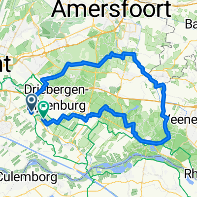
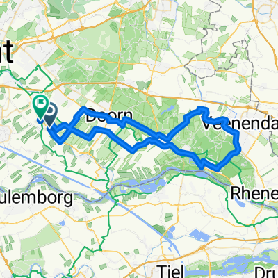
CYCLING THE RHINE: Route 03A
A cycling route starting in Driebergen-Rijsenburg, Utrecht, The Netherlands.
Overview
About this route
From Driebergen-Rijsenburg Info Centre to Rhenen railway station. Following the Old Rhine (Kromme Rijn) and the Nederrijn rivers.
Mostly paved, some unpaved and gravel surfaces.- -:--
- Duration
- 39.7 km
- Distance
- 39 m
- Ascent
- 26 m
- Descent
- ---
- Avg. speed
- ---
- Max. altitude
Route quality
Waytypes & surfaces along the route
Waytypes
Quiet road
17.5 km
(44 %)
Road
13.5 km
(34 %)
Surfaces
Paved
21.4 km
(54 %)
Unpaved
2 km
(5 %)
Asphalt
21.1 km
(53 %)
Gravel
1.2 km
(3 %)
Route highlights
Points of interest along the route
Accommodation after 0 km
Camping
Accommodation after 2.3 km
YOUTH HOSTEL: Stayokay Utrecht-Bunnik
Point of interest after 17.7 km
INFO VVV Office in the Town Square
Point of interest after 17.7 km
Remains of Duurstede Castle
Point of interest after 18.1 km
From here, you can cycle directly to Hoek van Holland / Europort if you prefer. See CYCLING THE RHINE: Route Approach D
Point of interest after 18.2 km
Rijn en Lek, 1659. The only remaining windmill built over a roadway in the Netherlands.
Accommodation after 20.5 km
Camping
Accommodation after 20.5 km
Camping
Accommodation after 32 km
NOTE: Elst Youth Hostel closed for good in September 2011.
Continue with Bikemap
Use, edit, or download this cycling route
You would like to ride CYCLING THE RHINE: Route 03A or customize it for your own trip? Here is what you can do with this Bikemap route:
Free features
- Save this route as favorite or in collections
- Copy & plan your own version of this route
- Sync your route with Garmin or Wahoo
Premium features
Free trial for 3 days, or one-time payment. More about Bikemap Premium.
- Navigate this route on iOS & Android
- Export a GPX / KML file of this route
- Create your custom printout (try it for free)
- Download this route for offline navigation
Discover more Premium features.
Get Bikemap PremiumFrom our community
Other popular routes starting in Driebergen-Rijsenburg
 Di-Wrkh-Holl Rading60Km
- Distance
- 58.6 km
- Ascent
- 129 m
- Descent
- 126 m
- Location
- Driebergen-Rijsenburg, Utrecht, The Netherlands
 RES-Rondje Woudb62Km
- Distance
- 60.7 km
- Ascent
- 238 m
- Descent
- 239 m
- Location
- Driebergen-Rijsenburg, Utrecht, The Netherlands
 A35 Wkh-Buren- Gmals30Km
- Distance
- 29.1 km
- Ascent
- 27 m
- Descent
- 27 m
- Location
- Driebergen-Rijsenburg, Utrecht, The Netherlands
 VR Wkh-RHENEN-71Km
- Distance
- 68.6 km
- Ascent
- 264 m
- Descent
- 262 m
- Location
- Driebergen-Rijsenburg, Utrecht, The Netherlands
 woon werk driebergen utrecht
- Distance
- 15.5 km
- Ascent
- 24 m
- Descent
- 24 m
- Location
- Driebergen-Rijsenburg, Utrecht, The Netherlands
 Rondje Driebergen met twee klimmetjes en tussenstop in Doorn
- Distance
- 24 km
- Ascent
- 114 m
- Descent
- 114 m
- Location
- Driebergen-Rijsenburg, Utrecht, The Netherlands
 A32-Bsch-Hvlakenk83
- Distance
- 83.9 km
- Ascent
- 165 m
- Descent
- 162 m
- Location
- Driebergen-Rijsenburg, Utrecht, The Netherlands
 A18-BWerkh-Veenendaal-57
- Distance
- 55.8 km
- Ascent
- 189 m
- Descent
- 186 m
- Location
- Driebergen-Rijsenburg, Utrecht, The Netherlands
Open it in the app