

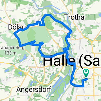
Nordwestlich von Halle
A cycling route starting in Halle, Saxony-Anhalt, Germany.
Overview
About this route
The route is moderately challenging, scenic, and is mostly low in car traffic.
In terms of distance, it can also be tackled 'quickly' after work or is ideal for acclimatization in spring.
As a loop, it can start anywhere; I chose the picturesque Kröllwitz Bridge with its socialist charm at the foot of the Giebichenstein castle ruins as my starting point.
There are two notable ascents of which one short but steep (about 1.5 km, 8%) can be skipped by turning directly to the Saale in Salzmünde and not climbing the 'mountain' over Gödewitz, although this also means missing out on a relaxing descent. The second ascent stretches from Wettin to Lettewitz moderately (6-8%), but over more than 5 km.
In Wettin, you have to take the ferry which crosses the Saale every few minutes. The costs for bike and rider in 2008 were 50 cents.
The path is almost entirely paved and therefore also well-suited for road bikes. On a real bike path, you rarely ride, but for example in Halle itself, where traffic is quite dense, it's most of the time.
- -:--
- Duration
- 43.8 km
- Distance
- 267 m
- Ascent
- 262 m
- Descent
- ---
- Avg. speed
- 155 m
- Max. altitude
Route quality
Waytypes & surfaces along the route
Waytypes
Road
17.5 km
(40 %)
Quiet road
9.2 km
(21 %)
Surfaces
Paved
38.1 km
(87 %)
Asphalt
38.1 km
(87 %)
Undefined
5.7 km
(13 %)
Route highlights
Points of interest along the route
Point of interest after 20.7 km
Schöne, kurze Fahrt per Fähre.
Continue with Bikemap
Use, edit, or download this cycling route
You would like to ride Nordwestlich von Halle or customize it for your own trip? Here is what you can do with this Bikemap route:
Free features
- Save this route as favorite or in collections
- Copy & plan your own version of this route
- Sync your route with Garmin or Wahoo
Premium features
Free trial for 3 days, or one-time payment. More about Bikemap Premium.
- Navigate this route on iOS & Android
- Export a GPX / KML file of this route
- Create your custom printout (try it for free)
- Download this route for offline navigation
Discover more Premium features.
Get Bikemap PremiumFrom our community
Other popular routes starting in Halle
 Hufeisen und zurück
- Distance
- 12.4 km
- Ascent
- 26 m
- Descent
- 26 m
- Location
- Halle, Saxony-Anhalt, Germany
 HALBLN 1
- Distance
- 152 km
- Ascent
- 525 m
- Descent
- 578 m
- Location
- Halle, Saxony-Anhalt, Germany
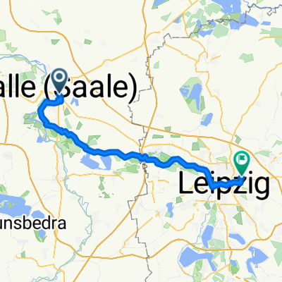 Halle nach Leipzig
- Distance
- 51.4 km
- Ascent
- 174 m
- Descent
- 166 m
- Location
- Halle, Saxony-Anhalt, Germany
 Über den Petersberg
- Distance
- 32.1 km
- Ascent
- 195 m
- Descent
- 195 m
- Location
- Halle, Saxony-Anhalt, Germany
 verirrte Fahrt
- Distance
- 28.5 km
- Ascent
- 69 m
- Descent
- 69 m
- Location
- Halle, Saxony-Anhalt, Germany
 Halle - Saaletal - Beesenstedt - Halle
- Distance
- 65.9 km
- Ascent
- 363 m
- Descent
- 363 m
- Location
- Halle, Saxony-Anhalt, Germany
 30 km Trainingsroute
- Distance
- 30.7 km
- Ascent
- 174 m
- Descent
- 173 m
- Location
- Halle, Saxony-Anhalt, Germany
 kurze Abendrunde um Halles Osten
- Distance
- 25.7 km
- Ascent
- 50 m
- Descent
- 53 m
- Location
- Halle, Saxony-Anhalt, Germany
Open it in the app