
Schönbrunn-Keilberg
A cycling route starting in Wolkenstein, Saxony, Germany.
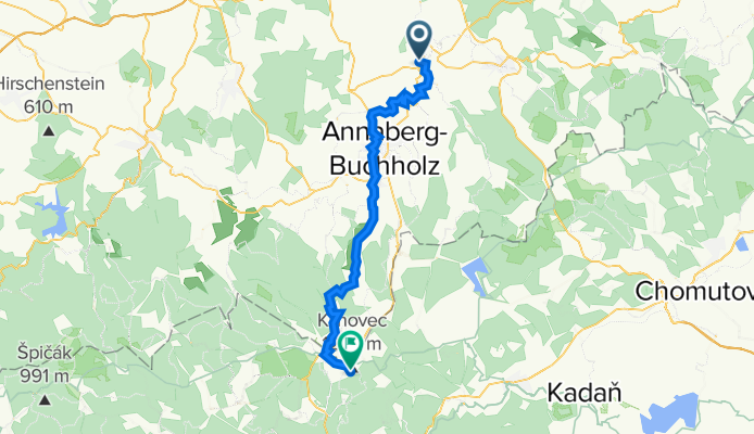
Overview
About this route
Actually intended for the return trip; via Sehma, Buchholz, Frohnau... maybe it would be better via Vierenstraße
- -:--
- Duration
- 44.1 km
- Distance
- 969 m
- Ascent
- 169 m
- Descent
- ---
- Avg. speed
- 1,228 m
- Max. altitude
Route quality
Waytypes & surfaces along the route
Waytypes
Track
15 km
(34 %)
Quiet road
8.8 km
(20 %)
Surfaces
Paved
33.1 km
(75 %)
Unpaved
7.1 km
(16 %)
Asphalt
28.2 km
(64 %)
Paved (undefined)
4.9 km
(11 %)
Continue with Bikemap
Use, edit, or download this cycling route
You would like to ride Schönbrunn-Keilberg or customize it for your own trip? Here is what you can do with this Bikemap route:
Free features
- Save this route as favorite or in collections
- Copy & plan your own version of this route
- Sync your route with Garmin or Wahoo
Premium features
Free trial for 3 days, or one-time payment. More about Bikemap Premium.
- Navigate this route on iOS & Android
- Export a GPX / KML file of this route
- Create your custom printout (try it for free)
- Download this route for offline navigation
Discover more Premium features.
Get Bikemap PremiumFrom our community
Other popular routes starting in Wolkenstein
 pressnitz - pockau
- Distance
- 54 km
- Ascent
- 594 m
- Descent
- 602 m
- Location
- Wolkenstein, Saxony, Germany
 Wolk-Eisenstr-Pock-Olb-Satz-Steinbach-Wolk
- Distance
- 97 km
- Ascent
- 939 m
- Descent
- 933 m
- Location
- Wolkenstein, Saxony, Germany
 Wolkenstein-Preßnitztalsperre-Fichtelberg-Wolkenstein
- Distance
- 109.2 km
- Ascent
- 1,033 m
- Descent
- 1,033 m
- Location
- Wolkenstein, Saxony, Germany
 Schönbrunn-Keilberg
- Distance
- 44.1 km
- Ascent
- 969 m
- Descent
- 169 m
- Location
- Wolkenstein, Saxony, Germany
 Schönbrunn-Christophhammer-Weipert-Schönbr.
- Distance
- 63.4 km
- Ascent
- 584 m
- Descent
- 584 m
- Location
- Wolkenstein, Saxony, Germany
 Erzgebirge 20160527
- Distance
- 59.8 km
- Ascent
- 451 m
- Descent
- 666 m
- Location
- Wolkenstein, Saxony, Germany
 HügelTourErzgebirge
- Distance
- 92.7 km
- Ascent
- 1,430 m
- Descent
- 1,433 m
- Location
- Wolkenstein, Saxony, Germany
 Erzgebirgshügeltour
- Distance
- 94.9 km
- Ascent
- 1,394 m
- Descent
- 1,394 m
- Location
- Wolkenstein, Saxony, Germany
Open it in the app