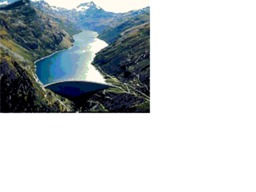
Tour 2011 Val di Lei
A cycling route starting in Trimmis, Grisons, Switzerland.
Overview
About this route
Tour to the reservoir
- -:--
- Duration
- 63.7 km
- Distance
- 1,793 m
- Ascent
- 423 m
- Descent
- ---
- Avg. speed
- ---
- Max. altitude
Route quality
Waytypes & surfaces along the route
Waytypes
Road
12.7 km
(20 %)
Quiet road
8.9 km
(14 %)
Surfaces
Paved
58 km
(91 %)
Unpaved
3.2 km
(5 %)
Asphalt
57.3 km
(90 %)
Gravel
2.5 km
(4 %)
Route highlights
Points of interest along the route

Point of interest after 63.7 km
Der Lago di Lei ist ein 8 km langer Stausee, der (wie der Lago di Livigno) fast vollständig in Italien liegt. Nur die 141 m hohe Staumauer und der 950 m lange Zufahrtstunnel liegen in der Schweiz, in einer Exklave der Gemeinde Ferrera oberhalb der Alp Campsut.
Continue with Bikemap
Use, edit, or download this cycling route
You would like to ride Tour 2011 Val di Lei or customize it for your own trip? Here is what you can do with this Bikemap route:
Free features
- Save this route as favorite or in collections
- Copy & plan your own version of this route
- Sync your route with Garmin or Wahoo
Premium features
Free trial for 3 days, or one-time payment. More about Bikemap Premium.
- Navigate this route on iOS & Android
- Export a GPX / KML file of this route
- Create your custom printout (try it for free)
- Download this route for offline navigation
Discover more Premium features.
Get Bikemap PremiumFrom our community
Other popular routes starting in Trimmis
 Tour 2011 Val di Lei
- Distance
- 63.7 km
- Ascent
- 1,793 m
- Descent
- 423 m
- Location
- Trimmis, Grisons, Switzerland
 Extensive Mittwoch Ride In Haldenstein
- Distance
- 5.5 km
- Ascent
- 60 m
- Descent
- 262 m
- Location
- Trimmis, Grisons, Switzerland
 Deutsche Strasse, Chur, Switzerland
- Distance
- 13.7 km
- Ascent
- 1,615 m
- Descent
- 41 m
- Location
- Trimmis, Grisons, Switzerland
 18-09 Transalp San Bernardino Tessin San Gotthard
- Distance
- 445.1 km
- Ascent
- 4,258 m
- Descent
- 4,259 m
- Location
- Trimmis, Grisons, Switzerland
 Trimmis nach tamins
- Distance
- 34.8 km
- Ascent
- 302 m
- Descent
- 354 m
- Location
- Trimmis, Grisons, Switzerland
 Etappe VII: Trimmis-Arbon
- Distance
- 95.7 km
- Ascent
- 66 m
- Descent
- 231 m
- Location
- Trimmis, Grisons, Switzerland
 18-07-11-13 3Tage Graubünden Tour
- Distance
- 212.3 km
- Ascent
- 3,399 m
- Descent
- 3,397 m
- Location
- Trimmis, Grisons, Switzerland
 susten
- Distance
- 276.3 km
- Ascent
- 3,756 m
- Descent
- 3,931 m
- Location
- Trimmis, Grisons, Switzerland
Open it in the app


