@AT: Gosausee runde
- 23.9 km
- 913 m
- 913 m
- Abtenau, Salzburg, Austria
A cycling route starting in Abtenau, Salzburg, Austria.
Overview
Cozy mountain bike tour with natural spectacle!
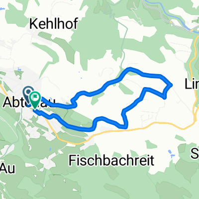
The starting point is the West parking lot in Abtenau. The ride goes towards the swimming pool. Pass by there and after the curve at the transformer station, turn left towards the Erlfeld district. Follow the road straight ahead. After a short descent, turn right towards Egelsee. Passing the farms, enter a short stretch of forest. Descend on a newly constructed road. At the second bend, continue straight. The paved road merges into a gravel path after the farm. Continue down this path until you reach the Lammer. Along the Lammer to the bridge on the left. Cross this and continue left on the municipal road until the Lammer bridge. Continue straight towards Pichl West and Weitenau. After the climb, pass through a short stretch of forest to the Aubach bridge. After the bridge, turn left towards Aubachfall. After the short climb, you can let the bike rest briefly and visit the waterfall.
Pass by the houses into the single trail (hiking path) towards Lammeröfen. After the single trail, follow the road up to Lammeröfen. At Lammeröfen (remarkable gorge - but only without a bike!) turn right onto the federal road and ride this until reaching the beginning of the village of Oberscheffau. Before the bridge, turn left and then immediately left again. Follow the Mill Path. At the Old Mill, you can visit the Schwarzenbach waterfall. The tour continues straight at the junction to the Old Mill on the forest road ascending. After a few bends uphill, you reach the Winner waterfall (which is usually dry in summer but impressive during snowmelt). After the climb, turn left into a short single trail that re-enters an old forest road along a ditch. Continue this upward to the new forest road. Continue upwards towards Abtenau via the Strubbergsattel. At the municipal border between Scheffau and Abtenau in the forest (barrier) is a historical border stone to admire. Descent from the Strubbergsattel into the district of Au in Abtenau. Passing the farms, turn right towards Abtenau. At the Aumühle inn, you can turn right to Dachserfall or Tricklfall. The Dachserfall is also accessible by bike. The last section of Tricklfall is only on foot. Both waterfalls are particularly impressive natural spectacles, especially during snowmelt. The route diverts about 200 m after the Aumühle inn to the left and leads the municipal road along the stream downhill. At the end of the paved road, turn right over the bridge and uphill to the federal road. Turn right into it and after about 150 m turn left again left. Continue straight, passing the sports facilities back to the starting point.
created this 17 years ago
Route highlights
Aubachfall
Lammeröfen (Lammerklamm)
Abzweigung zur "Alten Mühle" und Schwarzenbachfall
Winnerfall
Historischer Grenzstein
Strubbergsattel
Gassthof "Aumühle" Abzweigung zum Dachserfall bzw. Tricklfall
Continue with Bikemap
You would like to ride Wasserfalltour or customize it for your own trip? Here is what you can do with this Bikemap route:
Free trial for 3 days, or one-time payment. More about Bikemap Premium.
Discover more Premium features.
Get Bikemap PremiumFrom our community
Open it in the app