
Up&Down
A cycling route starting in Wängi, Thurgau, Switzerland.
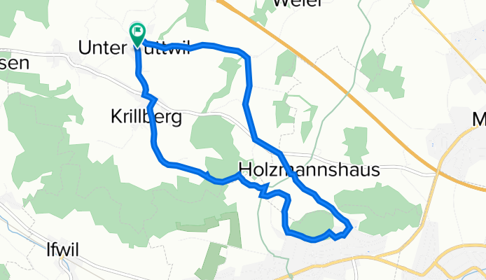
Overview
About this route
s Ufä&Abä Fescht
- -:--
- Duration
- 7.1 km
- Distance
- 232 m
- Ascent
- 228 m
- Descent
- ---
- Avg. speed
- 670 m
- Max. altitude
Route quality
Waytypes & surfaces along the route
Waytypes
Quiet road
4.2 km
(59 %)
Track
1.8 km
(25 %)
Surfaces
Paved
3.1 km
(43 %)
Unpaved
1.9 km
(27 %)
Asphalt
3.1 km
(43 %)
Gravel
1.5 km
(21 %)
Route highlights
Points of interest along the route
Point of interest after 3.7 km
Spielplatz Omi
Point of interest after 4.7 km
Tafel Säntisblick
Point of interest after 6 km
Dött wo Remo wohnt
Point of interest after 6.8 km
Start Schlittelpiste
Continue with Bikemap
Use, edit, or download this cycling route
You would like to ride Up&Down or customize it for your own trip? Here is what you can do with this Bikemap route:
Free features
- Save this route as favorite or in collections
- Copy & plan your own version of this route
- Sync your route with Garmin or Wahoo
Premium features
Free trial for 3 days, or one-time payment. More about Bikemap Premium.
- Navigate this route on iOS & Android
- Export a GPX / KML file of this route
- Create your custom printout (try it for free)
- Download this route for offline navigation
Discover more Premium features.
Get Bikemap PremiumFrom our community
Other popular routes starting in Wängi
 Sedel Aussichtspunkt_kurz
- Distance
- 11.6 km
- Ascent
- 154 m
- Descent
- 157 m
- Location
- Wängi, Thurgau, Switzerland
 Up&Down
- Distance
- 7.1 km
- Ascent
- 232 m
- Descent
- 228 m
- Location
- Wängi, Thurgau, Switzerland
 Vom Thurgau zurück
- Distance
- 71.5 km
- Ascent
- 1,049 m
- Descent
- 829 m
- Location
- Wängi, Thurgau, Switzerland
 Thur_Rundfahrt
- Distance
- 42.8 km
- Ascent
- 544 m
- Descent
- 546 m
- Location
- Wängi, Thurgau, Switzerland
 Töfflitour_Bichelsee
- Distance
- 33.8 km
- Ascent
- 732 m
- Descent
- 733 m
- Location
- Wängi, Thurgau, Switzerland
 Sedel Aussichtspunkt_lang
- Distance
- 15 km
- Ascent
- 178 m
- Descent
- 179 m
- Location
- Wängi, Thurgau, Switzerland
 Freudenberg
- Distance
- 13.8 km
- Ascent
- 166 m
- Descent
- 169 m
- Location
- Wängi, Thurgau, Switzerland
 Wiesengrundstrasse 33a, Wängi nach Hulftegg 907, Mosnang
- Distance
- 18.9 km
- Ascent
- 530 m
- Descent
- 166 m
- Location
- Wängi, Thurgau, Switzerland
Open it in the app