

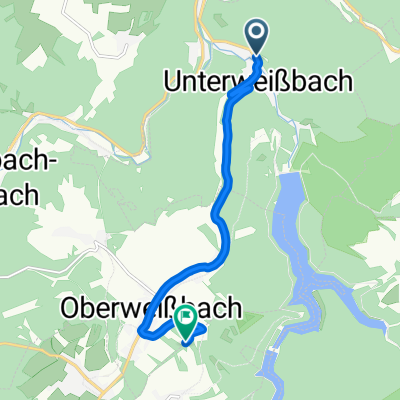
L1145, Unterweißbach nach L1145, Unterweißbach
A cycling route starting in Unterweißbach, Thuringia, Germany.
Overview
About this route
- 1 h 43 min
- Duration
- 22.1 km
- Distance
- 609 m
- Ascent
- 607 m
- Descent
- 12.8 km/h
- Avg. speed
- ---
- Max. altitude
Route quality
Waytypes & surfaces along the route
Waytypes
Access road
16.1 km
(73 %)
Track
5.8 km
(26 %)
Surfaces
Paved
16.1 km
(73 %)
Unpaved
5.9 km
(27 %)
Asphalt
16.1 km
(73 %)
Gravel
5.9 km
(27 %)
Undefined
0 km
(<1 %)
Continue with Bikemap
Use, edit, or download this cycling route
You would like to ride L1145, Unterweißbach nach L1145, Unterweißbach or customize it for your own trip? Here is what you can do with this Bikemap route:
Free features
- Save this route as favorite or in collections
- Copy & plan your own version of this route
- Sync your route with Garmin or Wahoo
Premium features
Free trial for 3 days, or one-time payment. More about Bikemap Premium.
- Navigate this route on iOS & Android
- Export a GPX / KML file of this route
- Create your custom printout (try it for free)
- Download this route for offline navigation
Discover more Premium features.
Get Bikemap PremiumFrom our community
Other popular routes starting in Unterweißbach
 Von Unterweißbach bis Bad Blankenburg im unterem Schwarzatal
- Distance
- 36 km
- Ascent
- 277 m
- Descent
- 277 m
- Location
- Unterweißbach, Thuringia, Germany
 u bis F turm
- Distance
- 7.5 km
- Ascent
- 450 m
- Descent
- 4 m
- Location
- Unterweißbach, Thuringia, Germany
 U bis F Turm
- Distance
- 7.5 km
- Ascent
- 451 m
- Descent
- 5 m
- Location
- Unterweißbach, Thuringia, Germany
 Runde Talsperre Leibis und Meurasteine
- Distance
- 26.3 km
- Ascent
- 801 m
- Descent
- 810 m
- Location
- Unterweißbach, Thuringia, Germany
 Route von Lichtetalstraße 31, Unterweißbach
- Distance
- 4.3 km
- Ascent
- 72 m
- Descent
- 63 m
- Location
- Unterweißbach, Thuringia, Germany
 Berggasthof Brandt-Lichte-Talsperre Leibis-Schmiedefeld-Roter Berg
- Distance
- 44.3 km
- Ascent
- 790 m
- Descent
- 790 m
- Location
- Unterweißbach, Thuringia, Germany
 Rund um die Trinkwassertalsperre Leibis
- Distance
- 26.8 km
- Ascent
- 621 m
- Descent
- 481 m
- Location
- Unterweißbach, Thuringia, Germany
 Einöde
- Distance
- 33.2 km
- Ascent
- 926 m
- Descent
- 484 m
- Location
- Unterweißbach, Thuringia, Germany
Open it in the app