

casa-aguacherri
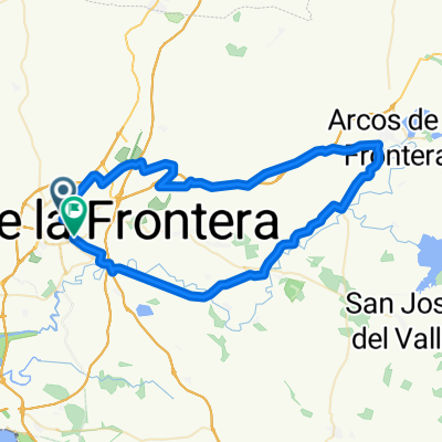
A cycling route starting in Jerez de la Frontera, Andalusia, Spain.
Overview
About this route
facil con desniveles alguna subida. para bici de montaña.a la altura de la cañada del carrillo el camino esta en muy mal estado durante unos 100m aproximadamente por lo que hay que bajarse de la bici, por lo demas esta muy bien.
tiene una dificultad moderada.
se tarda unas 2h y 15min. en completarla.
que la disfruteis.
- -:--
- Duration
- 33.6 km
- Distance
- 238 m
- Ascent
- 238 m
- Descent
- ---
- Avg. speed
- ---
- Max. altitude

Route quality
Waytypes & surfaces along the route
Waytypes
Track
21.3 km
(63 %)
Cycleway
4.3 km
(13 %)
Surfaces
Paved
11.7 km
(35 %)
Unpaved
4.8 km
(14 %)
Asphalt
10.9 km
(32 %)
Gravel
4.8 km
(14 %)
Continue with Bikemap
Use, edit, or download this cycling route
You would like to ride casa-aguacherri or customize it for your own trip? Here is what you can do with this Bikemap route:
Free features
- Save this route as favorite or in collections
- Copy & plan your own version of this route
- Sync your route with Garmin or Wahoo
Premium features
Free trial for 3 days, or one-time payment. More about Bikemap Premium.
- Navigate this route on iOS & Android
- Export a GPX / KML file of this route
- Create your custom printout (try it for free)
- Download this route for offline navigation
Discover more Premium features.
Get Bikemap PremiumFrom our community
Other popular routes starting in Jerez de la Frontera
 Tarifa - Stuttgart 14 Tage 3030km
- Distance
- 2,813.6 km
- Ascent
- 4,592 m
- Descent
- 4,287 m
- Location
- Jerez de la Frontera, Andalusia, Spain
 jerez - lagunas de aguaxerry - jerez
- Distance
- 42 km
- Ascent
- 309 m
- Descent
- 304 m
- Location
- Jerez de la Frontera, Andalusia, Spain
 1ª Eta J de la Frontera C.R.E 12;6 km
- Distance
- 12.7 km
- Ascent
- 73 m
- Descent
- 72 m
- Location
- Jerez de la Frontera, Andalusia, Spain
 casa-aguacherri
- Distance
- 33.6 km
- Ascent
- 238 m
- Descent
- 238 m
- Location
- Jerez de la Frontera, Andalusia, Spain
 Ruta Arcos.
- Distance
- 74.9 km
- Ascent
- 263 m
- Descent
- 263 m
- Location
- Jerez de la Frontera, Andalusia, Spain
 30-05-12
- Distance
- 25.2 km
- Ascent
- 363 m
- Descent
- 362 m
- Location
- Jerez de la Frontera, Andalusia, Spain
 1ª Eta Jerez de la Frontera , J de la Frontera 12,6 km C.R.E
- Distance
- 12.7 km
- Ascent
- 66 m
- Descent
- 66 m
- Location
- Jerez de la Frontera, Andalusia, Spain
 rutita por la campiña de Jerez de la Frontera
- Distance
- 49.8 km
- Ascent
- 214 m
- Descent
- 214 m
- Location
- Jerez de la Frontera, Andalusia, Spain
Open it in the app