

CNR - Trees UIO
A cycling route starting in Tutamandahostel, Pichincha, Ecuador.
Overview
About this route
Trees UIO
Discover Quito and its beautiful nature.
Time:<span style="white-space: pre;"> </span>2 hpurs
Distance:<span style="white-space: pre;"> </span>11 km
Altitude:<span style="white-space: pre;"> </span>2800 - 2857 msnm
Level:<span style="white-space: pre;"> </span>easy
ATTRACTIONS
Park: El Ejido, La Alameda, El Arbolito, La Carolina.
Others: Gonzales Suarez av., Jardin botanico de Quito.
Trees: Cedro, Cipress, Platan, Secoya, Palma de Quito, Palma Canaria, Eucalipto.
- -:--
- Duration
- 11 km
- Distance
- 0 m
- Ascent
- 0 m
- Descent
- ---
- Avg. speed
- ---
- Max. altitude

Route highlights
Points of interest along the route
Point of interest after 0 km
BIKING ECUADOR Wilson E7 96 & Diego de Almagro 593 2 542671 593 9 5041386 bikingecuador@gmail.com
Point of interest after 0 km
Quinde Square (Plaza Foch) Foch & Reina Victoria La Mariscal
Point of interest after 6.3 km
Gonzales Suarez Av.
Point of interest after 8.7 km
Jardin Botanico de Quito
Continue with Bikemap
Use, edit, or download this cycling route
You would like to ride CNR - Trees UIO or customize it for your own trip? Here is what you can do with this Bikemap route:
Free features
- Save this route as favorite or in collections
- Copy & plan your own version of this route
- Sync your route with Garmin or Wahoo
Premium features
Free trial for 3 days, or one-time payment. More about Bikemap Premium.
- Navigate this route on iOS & Android
- Export a GPX / KML file of this route
- Create your custom printout (try it for free)
- Download this route for offline navigation
Discover more Premium features.
Get Bikemap PremiumFrom our community
Other popular routes starting in Tutamandahostel
 CUN-Al Sur!!
- Distance
- 17.6 km
- Ascent
- 0 m
- Descent
- 0 m
- Location
- Tutamandahostel, Pichincha, Ecuador
 Masa Critica Quito Ruta Guapulo
- Distance
- 9.5 km
- Ascent
- 315 m
- Descent
- 314 m
- Location
- Tutamandahostel, Pichincha, Ecuador
 Antenas del Pichincha Carrosable
- Distance
- 15.5 km
- Ascent
- 1,163 m
- Descent
- 140 m
- Location
- Tutamandahostel, Pichincha, Ecuador
 CNR - Trees UIO
- Distance
- 11 km
- Ascent
- 0 m
- Descent
- 0 m
- Location
- Tutamandahostel, Pichincha, Ecuador
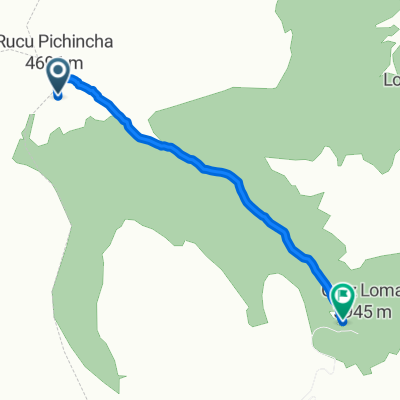 Rucu Pichincha
- Distance
- 4.8 km
- Ascent
- 316 m
- Descent
- 980 m
- Location
- Tutamandahostel, Pichincha, Ecuador
 Chirivuelta Quito- San Domingo
- Distance
- 143.1 km
- Ascent
- 7,366 m
- Descent
- 9,593 m
- Location
- Tutamandahostel, Pichincha, Ecuador
 CRONOESCALADA KUESTA KE KUESTA al Casitagua, sábado 3 sep 2011 AVAL CCMP
- Distance
- 7.5 km
- Ascent
- 983 m
- Descent
- 124 m
- Location
- Tutamandahostel, Pichincha, Ecuador
 Metro clockwise
- Distance
- 13.9 km
- Ascent
- 441 m
- Descent
- 441 m
- Location
- Tutamandahostel, Pichincha, Ecuador
Open it in the app