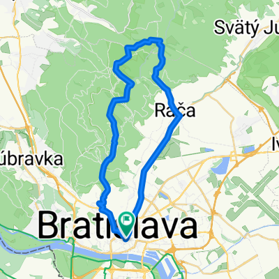
Trnavská cesta 164/48, Bratislava do Slnečná 4950/17, Pezinok
A cycling route starting in Bratislava, Bratislava Region, Slovakia.
Overview
About this route
- 1 h 18 min
- Duration
- 21.9 km
- Distance
- 40 m
- Ascent
- 13 m
- Descent
- 16.9 km/h
- Avg. speed
- 164 m
- Max. altitude
Route quality
Waytypes & surfaces along the route
Waytypes
Road
6.6 km
(30 %)
Quiet road
5.7 km
(26 %)
Surfaces
Paved
16.7 km
(76 %)
Asphalt
16.5 km
(75 %)
Wood
0.2 km
(<1 %)
Undefined
5.2 km
(24 %)
Continue with Bikemap
Use, edit, or download this cycling route
You would like to ride Trnavská cesta 164/48, Bratislava do Slnečná 4950/17, Pezinok or customize it for your own trip? Here is what you can do with this Bikemap route:
Free features
- Save this route as favorite or in collections
- Copy & plan your own version of this route
- Sync your route with Garmin or Wahoo
Premium features
Free trial for 3 days, or one-time payment. More about Bikemap Premium.
- Navigate this route on iOS & Android
- Export a GPX / KML file of this route
- Create your custom printout (try it for free)
- Download this route for offline navigation
Discover more Premium features.
Get Bikemap PremiumFrom our community
Other popular routes starting in Bratislava
- Road: Kopce na železnej studničke
- Distance
- 87.4 km
- Ascent
- 1,887 m
- Descent
- 1,882 m
- Location
- Bratislava, Bratislava Region, Slovakia
- poobedňajšia 50ka BA-Bernolákovo a späť
- Distance
- 50.3 km
- Ascent
- 47 m
- Descent
- 47 m
- Location
- Bratislava, Bratislava Region, Slovakia
- Bratislava - Kitsee - Jarovce - Rusovce
- Distance
- 31.2 km
- Ascent
- 14 m
- Descent
- 17 m
- Location
- Bratislava, Bratislava Region, Slovakia
- Bratislava - Vojka
- Distance
- 63.4 km
- Ascent
- 48 m
- Descent
- 50 m
- Location
- Bratislava, Bratislava Region, Slovakia
- Okolo Dunaja cez Vojku
- Distance
- 65.5 km
- Ascent
- 75 m
- Descent
- 75 m
- Location
- Bratislava, Bratislava Region, Slovakia
- Milanova80tka
- Distance
- 74.9 km
- Ascent
- 48 m
- Descent
- 48 m
- Location
- Bratislava, Bratislava Region, Slovakia
- Popri rieke Morave
- Distance
- 106.3 km
- Ascent
- 127 m
- Descent
- 127 m
- Location
- Bratislava, Bratislava Region, Slovakia
- na Veľký Javorník a späť
- Distance
- 39.4 km
- Ascent
- 550 m
- Descent
- 550 m
- Location
- Bratislava, Bratislava Region, Slovakia
Open it in the app