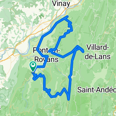
Drome 2011 - 02

A cycling route starting in Saint-Jean-en-Royans, Auvergne-Rh么ne-Alpes, France.

Overview

About this route

-:--
Duration
67.8 km
Distance
1,808 m
Ascent
1,808 m
Descent
---
Avg. speed
---
Max. altitude
db

created this 14 years ago

Route quality

Waytypes & surfaces along the route

Route highlights

Points of interest along the route

  1. Point of interest after 8.5 km

    <b>Col Gaudissart</b> <br />FR-26-0889a <a href="http://dbossard.free.fr/Drome2011.html">Test</a>

  2. Point of interest after 12.1 km

    <b>Col de la Machine </b> <br />FR-26-1011

  3. Point of interest after 19.7 km

    <b>Col de Carri </b> <br />FR-26-1202

  4. Point of interest after 28 km

    <b>Col de Proncel</b> <br />FR-26-1100f

  5. Point of interest after 36.2 km

    <b>Col de la Chau </b> <br />FR-26-1337a

  6. Point of interest after 38.7 km

    <b>Col du Chaud Clapier</b> <br />FR-26-1412a

  7. Point of interest after 44.3 km

    <b>Col de la Rama</b> <br />FR-26-1279

  8. Point of interest after 48 km

    <b>Col de Taillebourse</b> <br />FR-26-1165a

  9. Point of interest after 53 km

    <b>Col de l'Echarasson</b> <br />FR-26-1146

  10. Point of interest after 58.5 km

    <b>Pas de la Serre</b> <br />FR-26-0914

Continue with Bikemap

Use, edit, or download this cycling route

You would like to ride Drome 2011 - 02 or customize it for your own trip? Here is what you can do with this Bikemap route:

Free features

Premium features

Free trial for 3 days, or one-time payment. More about Bikemap Premium.

  • Navigate this route on iOS & Android
  • Export a GPX / KML file of this route
  • Create your custom printout (try it for free)
  • Download this route for offline navigation

Discover more Premium features.

Get Bikemap Premium

From our community

Other popular routes starting in Saint-Jean-en-Royans

Open it in the app