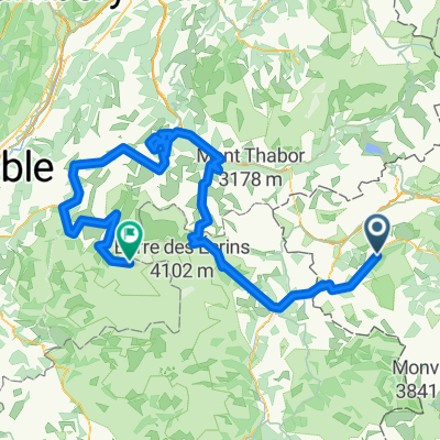
Sestriere (e20 Giro)
- 10.5 km
- 528 m
- 0 m
- Pragelato, Piedmont, Italy
A cycling route starting in Pragelato, Piedmont, Italy.
Overview
La lapide che ricorda la valanga del Beth si trova poco alta sul fondovalle, affissa a una roccia nella zona in cui furono recuperate le salme dei minatori. Si può raggiungere solo a piedi in una decina di minuti di discesa su sentiero segnalato dalla Borgata Troncea. Oppure con breve salita dal fondovalle: dalla località Fournet sentiero per Troncea.
Consiglio di viaggio molto semplice: dall’area di sosta poco dopo Laval si va sulla strada bianca di fondovalle fino alla Bergeria del Meys, a 2000 metri di quota (consigliabile bici da sterrato). A circa metà valle una deviazione conduce a Troncea, dove si trova l’omonimo rifugio.
La strada di fondovalle e la deviazione per Troncea sono percorribili in bicicletta. Tutti gli altri percorsi del parco sono invece riservati agli escursionisti.
Strada chiusa ai mezzi motorizzati. Nel periodo estivo è attivo un servizio di navetta per Troncea e per il Meys.
Una mostra sulla valanga del Beth è esposta alla sede del parco a Pragelato.
created this 4 years ago
Route quality
Track
4.5 km
97 %
Quiet road
0.1 km
2 %
Path
0 km
1 %
Unpaved
4.6 km
(99 %)
Gravel
4.6 km
99 %
Undefined
0 km
1 %
Route highlights
Borgata Laval

Borgata e Rifugio Troncea

Lapide della valanga del Beth
Continue with Bikemap
You would like to ride Elogio della lapide della valanga del Beth in Val Troncea or customize it for your own trip? Here is what you can do with this Bikemap route:
Free trial for 3 days, or one-time payment. More about Bikemap Premium.
Discover more Premium features.
Get Bikemap PremiumFrom our community
Open it in the app