

Zelz-Felixsee-Kromlau-Bad Muskau-Zelz
A cycling route starting in Trzebiel, Lubusz Voivodship, Poland.
Overview
About this route
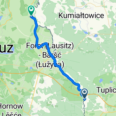
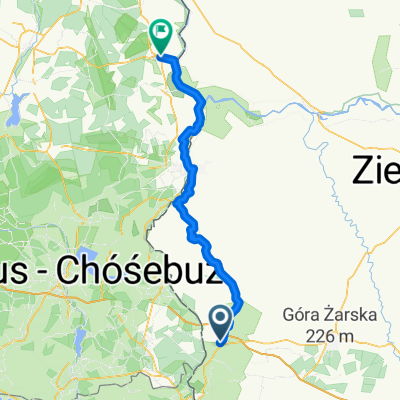
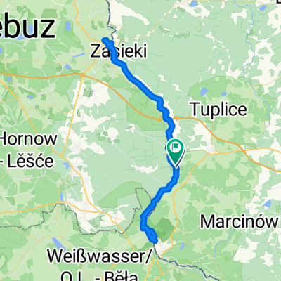
Start and finish at the pedestrian-bicycle crossing Siedlec/Zelz. Beginning of the loop; to Jerischke (about 4 km) along a road with little vehicle traffic. From Jerischke to the end, the route runs on asphalted, marked bike paths.
On the segment Döbern-Bohsdorf, we discover a geological-mining exhibition in the forest. Further behind Bohsdorf, entry to the 35m observation tower - Felixsee. In Friedrischhein, we pass by the station building with an exhibition! After crossing the border of the states of Brandenburg and Saxony, entry to Rhododendronpark Kromlau and a visit to the forest railway station. The route in Bad Muskau runs along the border of the Muskau Park, but we do not enter it.
- -:--
- Duration
- 51.5 km
- Distance
- 199 m
- Ascent
- 199 m
- Descent
- ---
- Avg. speed
- ---
- Max. altitude

Route quality
Waytypes & surfaces along the route
Waytypes
Quiet road
22.7 km
(44 %)
Track
10.3 km
(20 %)
Surfaces
Paved
41.2 km
(80 %)
Unpaved
3.1 km
(6 %)
Asphalt
36.6 km
(71 %)
Concrete
3.6 km
(7 %)
Continue with Bikemap
Use, edit, or download this cycling route
You would like to ride Zelz-Felixsee-Kromlau-Bad Muskau-Zelz or customize it for your own trip? Here is what you can do with this Bikemap route:
Free features
- Save this route as favorite or in collections
- Copy & plan your own version of this route
- Sync your route with Garmin or Wahoo
Premium features
Free trial for 3 days, or one-time payment. More about Bikemap Premium.
- Navigate this route on iOS & Android
- Export a GPX / KML file of this route
- Create your custom printout (try it for free)
- Download this route for offline navigation
Discover more Premium features.
Get Bikemap PremiumFrom our community
Other popular routes starting in Trzebiel
 Zelz-Felixsee-Kromlau-Bad Muskau-Zelz
- Distance
- 51.5 km
- Ascent
- 199 m
- Descent
- 199 m
- Location
- Trzebiel, Lubusz Voivodship, Poland
 (PL)/Zelz - Döbern - Bagenz - Cottbus - Forst - Zelz/(PL)
- Distance
- 91.5 km
- Ascent
- 168 m
- Descent
- 168 m
- Location
- Trzebiel, Lubusz Voivodship, Poland
 Trzebiel - Brody
- Distance
- 26.9 km
- Ascent
- 47 m
- Descent
- 74 m
- Location
- Trzebiel, Lubusz Voivodship, Poland
 Słowackiego do Alte Poststraße
- Distance
- 89.4 km
- Ascent
- 300 m
- Descent
- 378 m
- Location
- Trzebiel, Lubusz Voivodship, Poland
 Z Zelz przez Groß Kölzig, Sergen, Cottbus do Peitz
- Distance
- 107 km
- Ascent
- 193 m
- Descent
- 193 m
- Location
- Trzebiel, Lubusz Voivodship, Poland
 Słowackiego 10, Trzebiel do Szkolna 9, Brody
- Distance
- 41.3 km
- Ascent
- 73 m
- Descent
- 63 m
- Location
- Trzebiel, Lubusz Voivodship, Poland
 Trasa spokojna
- Distance
- 37.7 km
- Ascent
- 549 m
- Descent
- 532 m
- Location
- Trzebiel, Lubusz Voivodship, Poland
 Route in Neiße-Malxetal
- Distance
- 63.6 km
- Ascent
- 417 m
- Descent
- 415 m
- Location
- Trzebiel, Lubusz Voivodship, Poland
Open it in the app