

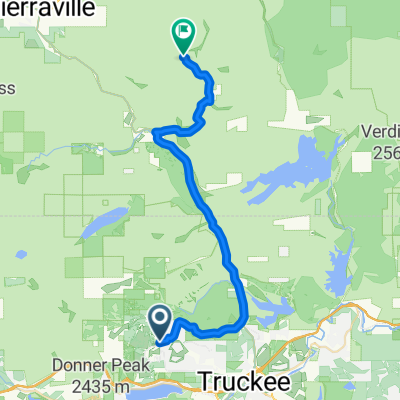
Sawtooth/Tahoe Rim Trail
A cycling route starting in Truckee, California, United States.
Overview
About this route
- -:--
- Duration
- 56 km
- Distance
- 1,300 m
- Ascent
- 1,301 m
- Descent
- ---
- Avg. speed
- 2,401 m
- Max. altitude

Route quality
Waytypes & surfaces along the route
Waytypes
Path
20.2 km
(36 %)
Track
18.5 km
(33 %)
Surfaces
Paved
29.7 km
(53 %)
Unpaved
26.3 km
(47 %)
Asphalt
29.7 km
(53 %)
Ground
15.1 km
(27 %)
Loose gravel
11.2 km
(20 %)
Continue with Bikemap
Use, edit, or download this cycling route
You would like to ride Sawtooth/Tahoe Rim Trail or customize it for your own trip? Here is what you can do with this Bikemap route:
Free features
- Save this route as favorite or in collections
- Copy & plan your own version of this route
- Sync your route with Garmin or Wahoo
Premium features
Free trial for 3 days, or one-time payment. More about Bikemap Premium.
- Navigate this route on iOS & Android
- Export a GPX / KML file of this route
- Create your custom printout (try it for free)
- Download this route for offline navigation
Discover more Premium features.
Get Bikemap PremiumFrom our community
Other popular routes starting in Truckee
 Truckee - Verdi
- Distance
- 37 km
- Ascent
- 657 m
- Descent
- 721 m
- Location
- Truckee, California, United States
 Easy Trail
- Distance
- 9.7 km
- Ascent
- 190 m
- Descent
- 192 m
- Location
- Truckee, California, United States
 Steady ride in Truckee
- Distance
- 9.4 km
- Ascent
- 294 m
- Descent
- 291 m
- Location
- Truckee, California, United States
 Epic Loop
- Distance
- 57.1 km
- Ascent
- 805 m
- Descent
- 803 m
- Location
- Truckee, California, United States
 Gold Bend, Truckee to Gold Bend, Truckee
- Distance
- 18.6 km
- Ascent
- 397 m
- Descent
- 398 m
- Location
- Truckee, California, United States
 Gold Bend, Truckee to Gold Bend, Truckee
- Distance
- 18.7 km
- Ascent
- 397 m
- Descent
- 398 m
- Location
- Truckee, California, United States
 Sawtooth/Tahoe Rim Trail
- Distance
- 56 km
- Ascent
- 1,300 m
- Descent
- 1,301 m
- Location
- Truckee, California, United States
 Big Loop
- Distance
- 31.5 km
- Ascent
- 1,011 m
- Descent
- 1,012 m
- Location
- Truckee, California, United States
Open it in the app