

Žacléř – okolo Vraních hor - Žacléř
A cycling route starting in Žacléř, Královéhradecký kraj, Czechia.
Overview
About this route
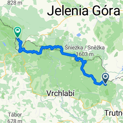
Exploring the entire mountain range in one afternoon is not something that happens very often, but in the case of the Vraní mountains, it is an opportunity for an interesting trip. Soon after starting from Rýchorské Square, you'll have the rugged massif with the highest peak, Špičák, right in front of you. And that for most of the way to the border crossing at Královec. Next will be Lubawka, and at its edge the turnoff to Chelmsko Śląskie, where it is worth making a stop. The square is surrounded by historic town houses, at the top there is an interesting baroque church of the Holy Family, and nearby a group of buildings known as the Twelve Apostles, built in the early 18th century for Czech weavers. The next path leads from the square towards the border crossing Okrzeszyn - Petříkovice. The Vraní mountains are on your right side, and just past Chelmsko, you can observe how their character has changed from the Polish side. No steep slopes, but gently rising hills in the landscape. Soon after returning to the Czech Republic, the route will connect to the main road and lead you to Trutnov Poříčí, from where the return to Královec begins. At the Voletiny sign, you'll connect to the blue bike route of the Žacléřsko microregion, which will lead you around the Dead Lake, Hony, and the settlement of Rybníček to Bečkov, or to the sign under the hexagonal chapel. From here, you can continue either along the slope of Špičák (off-road version) or through the village of Bernartice (road). From Královec to Žacléř, you'll then return along the same road. Important points: Žacléř - Královec - Lubawka - Chelmsko Śląskie - Petříkovice - Hony - Bernartice - Královec - Žacléř
- -:--
- Duration
- 55.4 km
- Distance
- 495 m
- Ascent
- 495 m
- Descent
- ---
- Avg. speed
- ---
- Max. altitude
Route highlights
Points of interest along the route

Photo after 2.4 km

Photo after 5.1 km

Photo after 8.5 km

Photo after 10.5 km

Photo after 11 km

Photo after 11.1 km

Photo after 12.2 km

Photo after 13.1 km

Photo after 14.2 km

Photo after 14.5 km

Photo after 14.7 km

Photo after 14.7 km

Photo after 16.4 km

Photo after 16.8 km

Photo after 16.9 km

Photo after 17.8 km

Photo after 17.8 km

Photo after 51.9 km
Continue with Bikemap
Use, edit, or download this cycling route
You would like to ride Žacléř – okolo Vraních hor - Žacléř or customize it for your own trip? Here is what you can do with this Bikemap route:
Free features
- Save this route as favorite or in collections
- Copy & plan your own version of this route
- Sync your route with Garmin or Wahoo
Premium features
Free trial for 3 days, or one-time payment. More about Bikemap Premium.
- Navigate this route on iOS & Android
- Export a GPX / KML file of this route
- Create your custom printout (try it for free)
- Download this route for offline navigation
Discover more Premium features.
Get Bikemap PremiumFrom our community
Other popular routes starting in Žacléř
 Žacléř – okolo Vraních hor - Žacléř
- Distance
- 55.4 km
- Ascent
- 495 m
- Descent
- 495 m
- Location
- Žacléř, Královéhradecký kraj, Czechia
 Mala Upa - aussichtsturm eliska
- Distance
- 21.3 km
- Ascent
- 718 m
- Descent
- 322 m
- Location
- Žacléř, Královéhradecký kraj, Czechia
 Žacléř-Adršpach-Žacléř
- Distance
- 65.1 km
- Ascent
- 712 m
- Descent
- 711 m
- Location
- Žacléř, Královéhradecký kraj, Czechia
 náměstí Josefa Čapka, Žacléř do Droga bez nazwy
- Distance
- 23.8 km
- Ascent
- 700 m
- Descent
- 379 m
- Location
- Žacléř, Královéhradecký kraj, Czechia
 Spálený Mlýn-Černá h.-Pec pod S.-Spálený m.
- Distance
- 37.7 km
- Ascent
- 1,195 m
- Descent
- 1,196 m
- Location
- Žacléř, Královéhradecký kraj, Czechia
 Test
Test- Distance
- 32.1 km
- Ascent
- 302 m
- Descent
- 434 m
- Location
- Žacléř, Královéhradecký kraj, Czechia
 Mala Upa - Pec a zpět - Elektrokola
- Distance
- 33.3 km
- Ascent
- 990 m
- Descent
- 955 m
- Location
- Žacléř, Královéhradecký kraj, Czechia
 Karkonosze Day 2 v1
- Distance
- 61.6 km
- Ascent
- 1,550 m
- Descent
- 1,717 m
- Location
- Žacléř, Královéhradecký kraj, Czechia
Open it in the app