

Žacléř – Prkenný Důl - Rýchory - Žacléř
A cycling route starting in Žacléř, Královéhradecký kraj, Czechia.
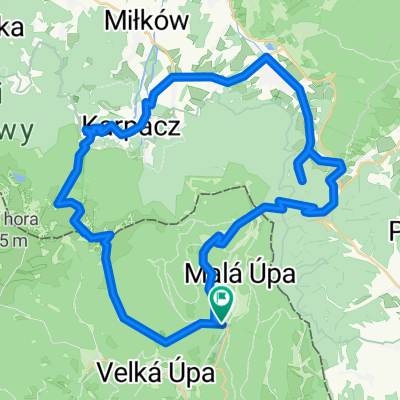
Overview
About this route
Stachelberg Fortress, romantic Snowy Cottages, Rýchory with the I zone of the national park and overgrown Scottish Highland cattle. And in favorable weather, beautiful views to boot. All this is offered by this (at least in terms of kilometers) short route. But... At the beginning you must conquer one of the longest climbs around. There's no need to be afraid, but a certain physical foundation is required. From Rýchorské Square you ride down to Prkenný Důl, pass a pond and in a sharp left curve turn right. Here is the lowest point of the route (475 m). End of the descent and the ascent begins. Around Stachelberg, across the main road up to the Rýchor Forest: 6 kilometers and 500 meters of elevation. Here at the intersection you turn towards the Snowy Cottages with a view of the Vraní Mountains and into Poland. A bit further on is the highest point of the route, 1000 meters above sea level. From here you start descending to the road between Žacléř and the Rýchorská hut, which you will see directly in front of you. If you want, just turn left and in less than a kilometer you will be there. Right by the road there is also a pen with a small herd of Scottish Highland cattle. To return to Žacléř, you must turn right. Next, there will be a five-kilometer descent around the Hubertus hut up to the Rýchorské Square.
- -:--
- Duration
- 16.2 km
- Distance
- 527 m
- Ascent
- 527 m
- Descent
- ---
- Avg. speed
- ---
- Max. altitude
Route highlights
Points of interest along the route

Photo after 9.2 km

Photo after 9.6 km

Photo after 10.1 km

Photo after 10.2 km

Photo after 10.6 km

Photo after 11.5 km

Photo after 11.8 km

Photo after 11.9 km

Photo after 12.2 km

Photo after 12.3 km

Photo after 12.4 km
Continue with Bikemap
Use, edit, or download this cycling route
You would like to ride Žacléř – Prkenný Důl - Rýchory - Žacléř or customize it for your own trip? Here is what you can do with this Bikemap route:
Free features
- Save this route as favorite or in collections
- Copy & plan your own version of this route
- Sync your route with Garmin or Wahoo
Premium features
Free trial for 3 days, or one-time payment. More about Bikemap Premium.
- Navigate this route on iOS & Android
- Export a GPX / KML file of this route
- Create your custom printout (try it for free)
- Download this route for offline navigation
Discover more Premium features.
Get Bikemap PremiumFrom our community
Other popular routes starting in Žacléř
 Okruh Žacléř – Adršpach – Žacléř
- Distance
- 68.8 km
- Ascent
- 803 m
- Descent
- 797 m
- Location
- Žacléř, Královéhradecký kraj, Czechia
 Žacléř-Adršpach-Žacléř
- Distance
- 65.1 km
- Ascent
- 712 m
- Descent
- 711 m
- Location
- Žacléř, Královéhradecký kraj, Czechia
 Spálený Mlýn-Černá h.-Pec pod S.-Spálený m.
- Distance
- 37.7 km
- Ascent
- 1,195 m
- Descent
- 1,196 m
- Location
- Žacléř, Královéhradecký kraj, Czechia
 náměstí Josefa Čapka, Žacléř do Droga bez nazwy
- Distance
- 23.8 km
- Ascent
- 700 m
- Descent
- 379 m
- Location
- Žacléř, Královéhradecký kraj, Czechia
 Žacléř – Prkenný Důl - Rýchory - Žacléř
- Distance
- 16.2 km
- Ascent
- 527 m
- Descent
- 527 m
- Location
- Žacléř, Královéhradecký kraj, Czechia
 Žacléř – Horní Albeřice – Niedamirów (PL) - Žacléř
- Distance
- 16.9 km
- Ascent
- 452 m
- Descent
- 449 m
- Location
- Žacléř, Královéhradecký kraj, Czechia
 Mala Upa - Pec a zpět - Elektrokola
- Distance
- 33.3 km
- Ascent
- 990 m
- Descent
- 955 m
- Location
- Žacléř, Královéhradecký kraj, Czechia
 PŘ 16 - Od Spáleného Mlýna na Sněžku přes Polsko
- Distance
- 39.8 km
- Ascent
- 1,387 m
- Descent
- 1,385 m
- Location
- Žacléř, Královéhradecký kraj, Czechia
Open it in the app