
MONTAÑAS VACÍAS OCTUBRE 21
20211024 Molina de Aragón - Teruel
A cycling route starting in Molina de Aragón, Castille-La Mancha, Spain.
Overview
About this route
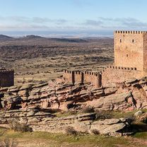
20211024 MMVV 05
- -:--
- Duration
- 118.1 km
- Distance
- 993 m
- Ascent
- 1,123 m
- Descent
- ---
- Avg. speed
- 1,389 m
- Max. altitude

Part of
MONTAÑAS VACÍAS OCTUBRE 21
5 stages
Route photos


Route quality
Waytypes & surfaces along the route
Waytypes
Track
37.8 km
(32 %)
Cycleway
27.2 km
(23 %)
Surfaces
Paved
47.2 km
(40 %)
Unpaved
8.3 km
(7 %)
Paved (undefined)
43.7 km
(37 %)
Gravel
4.7 km
(4 %)
Continue with Bikemap
Use, edit, or download this cycling route
You would like to ride 20211024 Molina de Aragón - Teruel or customize it for your own trip? Here is what you can do with this Bikemap route:
Free features
- Save this route as favorite or in collections
- Copy & plan your own version of this route
- Split it into stages to create a multi-day tour
- Sync your route with Garmin or Wahoo
Premium features
Free trial for 3 days, or one-time payment. More about Bikemap Premium.
- Navigate this route on iOS & Android
- Export a GPX / KML file of this route
- Create your custom printout (try it for free)
- Download this route for offline navigation
Discover more Premium features.
Get Bikemap PremiumFrom our community
Other popular routes starting in Molina de Aragón
 CaminoCid3.3_Molina de Aragon to Monreal del Campo
- Distance
- 56.6 km
- Ascent
- 454 m
- Descent
- 576 m
- Location
- Molina de Aragón, Castille-La Mancha, Spain
 Molina de Aragón - Checa
- Distance
- 61.6 km
- Ascent
- 859 m
- Descent
- 591 m
- Location
- Molina de Aragón, Castille-La Mancha, Spain
 Molina de Aragón - Cella
- Distance
- 95.1 km
- Ascent
- 933 m
- Descent
- 996 m
- Location
- Molina de Aragón, Castille-La Mancha, Spain
 Torre de incendios de Molina - Fuente del Cura - Rillo
- Distance
- 23.1 km
- Ascent
- 388 m
- Descent
- 381 m
- Location
- Molina de Aragón, Castille-La Mancha, Spain
 MOLINA DE ARAGON-ALMAZAN
- Distance
- 116.2 km
- Ascent
- 704 m
- Descent
- 836 m
- Location
- Molina de Aragón, Castille-La Mancha, Spain
 2-Molina-Peralejos
- Distance
- 79.3 km
- Ascent
- 414 m
- Descent
- 289 m
- Location
- Molina de Aragón, Castille-La Mancha, Spain
 Molina_de_Aragon-Galve_carretera
- Distance
- 125.8 km
- Ascent
- 985 m
- Descent
- 873 m
- Location
- Molina de Aragón, Castille-La Mancha, Spain
 Etapa 2. Molina de Aragón - Albarracín
- Distance
- 77.9 km
- Ascent
- 3,787 m
- Descent
- 3,995 m
- Location
- Molina de Aragón, Castille-La Mancha, Spain
Open it in the app