

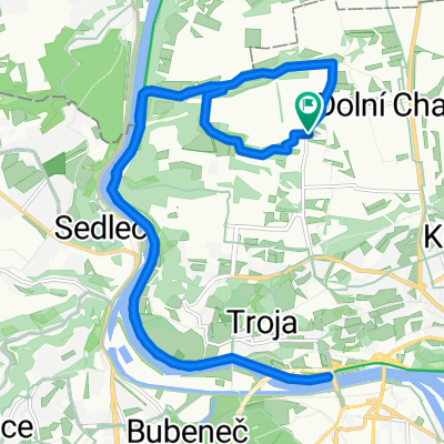
Cimice - Okor - Cimice
A cycling route starting in Roztoky, Central Bohemia, Czechia.
Overview
About this route
A slightly undulating route mainly along the road. But there is also a bit of nature there :-)
- -:--
- Duration
- 57.5 km
- Distance
- 408 m
- Ascent
- 410 m
- Descent
- ---
- Avg. speed
- ---
- Max. altitude

Route quality
Waytypes & surfaces along the route
Waytypes
Road
25.3 km
(44 %)
Quiet road
10.9 km
(19 %)
Surfaces
Paved
39.7 km
(69 %)
Unpaved
6.3 km
(11 %)
Asphalt
39.1 km
(68 %)
Gravel
4 km
(7 %)
Route highlights
Points of interest along the route

Photo after 27.7 km
Okoř
Continue with Bikemap
Use, edit, or download this cycling route
You would like to ride Cimice - Okor - Cimice or customize it for your own trip? Here is what you can do with this Bikemap route:
Free features
- Save this route as favorite or in collections
- Copy & plan your own version of this route
- Sync your route with Garmin or Wahoo
Premium features
Free trial for 3 days, or one-time payment. More about Bikemap Premium.
- Navigate this route on iOS & Android
- Export a GPX / KML file of this route
- Create your custom printout (try it for free)
- Download this route for offline navigation
Discover more Premium features.
Get Bikemap PremiumFrom our community
Other popular routes starting in Roztoky
 Od Vltavy na Okoř a zpátky (okruh)
- Distance
- 24 km
- Ascent
- 285 m
- Descent
- 285 m
- Location
- Roztoky, Central Bohemia, Czechia
 Route to Základní Škola Pro Děti s Kombinovaným Postižením Smiling Crocodile
- Distance
- 22.2 km
- Ascent
- 186 m
- Descent
- 211 m
- Location
- Roztoky, Central Bohemia, Czechia
 Čimice - podél Vltavy - Klecánky - Klecany - Líbeznice - a zpět
- Distance
- 32.5 km
- Ascent
- 378 m
- Descent
- 378 m
- Location
- Roztoky, Central Bohemia, Czechia
 Čimice - Draháňské údolí - Toja - Čimické údolí - Čimice
- Distance
- 20.4 km
- Ascent
- 182 m
- Descent
- 182 m
- Location
- Roztoky, Central Bohemia, Czechia
 Na sever od Čimic z Prahy po silnici
- Distance
- 53.3 km
- Ascent
- 305 m
- Descent
- 305 m
- Location
- Roztoky, Central Bohemia, Czechia
 Kralupy Brandýsek Únětice
- Distance
- 84.8 km
- Ascent
- 326 m
- Descent
- 328 m
- Location
- Roztoky, Central Bohemia, Czechia
 ROKYTKA POČERNICE KBELY KOBYLISY
- Distance
- 49.4 km
- Ascent
- 195 m
- Descent
- 195 m
- Location
- Roztoky, Central Bohemia, Czechia
 velké lávkové kolečko Troja Veltrusy
- Distance
- 56.7 km
- Ascent
- 218 m
- Descent
- 218 m
- Location
- Roztoky, Central Bohemia, Czechia
Open it in the app