

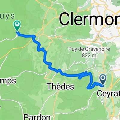
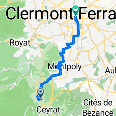
De 39 Avenue Wilson, Ceyrat à 104 Avenue de la Libération, Clermont-Ferrand
A cycling route starting in Ceyrat, Auvergne-Rhône-Alpes, France.
Overview
About this route
- 10 min
- Duration
- 4.3 km
- Distance
- 33 m
- Ascent
- 204 m
- Descent
- 26.2 km/h
- Avg. speed
- ---
- Max. altitude
Route quality
Waytypes & surfaces along the route
Waytypes
Busy road
3.2 km
(73 %)
Quiet road
1.1 km
(24 %)
Surfaces
Paved
2.4 km
(54 %)
Asphalt
2.4 km
(54 %)
Undefined
2 km
(46 %)
Continue with Bikemap
Use, edit, or download this cycling route
You would like to ride De 39 Avenue Wilson, Ceyrat à 104 Avenue de la Libération, Clermont-Ferrand or customize it for your own trip? Here is what you can do with this Bikemap route:
Free features
- Save this route as favorite or in collections
- Copy & plan your own version of this route
- Sync your route with Garmin or Wahoo
Premium features
Free trial for 3 days, or one-time payment. More about Bikemap Premium.
- Navigate this route on iOS & Android
- Export a GPX / KML file of this route
- Create your custom printout (try it for free)
- Download this route for offline navigation
Discover more Premium features.
Get Bikemap PremiumFrom our community
Other popular routes starting in Ceyrat
 ceyrat beubeule
- Distance
- 8.1 km
- Ascent
- 352 m
- Descent
- 351 m
- Location
- Ceyrat, Auvergne-Rhône-Alpes, France
 Tour 8 (Clermont Ferrand - Tulle)
- Distance
- 158.5 km
- Ascent
- 1,137 m
- Descent
- 1,514 m
- Location
- Ceyrat, Auvergne-Rhône-Alpes, France
 1 Chemin du Roudadoux, Ceyrat nach Cht de Montlosier, Aydat
- Distance
- 13.9 km
- Ascent
- 514 m
- Descent
- 130 m
- Location
- Ceyrat, Auvergne-Rhône-Alpes, France
 Fontimbert-La Roche Blanche-Romagnat
- Distance
- 22.9 km
- Ascent
- 477 m
- Descent
- 522 m
- Location
- Ceyrat, Auvergne-Rhône-Alpes, France
 De 7 Allée des Noyers, Ceyrat à 8 Rue du Docteur Georges Digue, Aubière
- Distance
- 5.3 km
- Ascent
- 45 m
- Descent
- 228 m
- Location
- Ceyrat, Auvergne-Rhône-Alpes, France
 puy de Dome
- Distance
- 11.8 km
- Ascent
- 500 m
- Descent
- 199 m
- Location
- Ceyrat, Auvergne-Rhône-Alpes, France
 Chemin du Roudadoux, Ceyrat nach Boulevard Desaix, Clermont-Ferrand
- Distance
- 7.4 km
- Ascent
- 79 m
- Descent
- 278 m
- Location
- Ceyrat, Auvergne-Rhône-Alpes, France
 trace ceyrat
- Distance
- 7.6 km
- Ascent
- 318 m
- Descent
- 321 m
- Location
- Ceyrat, Auvergne-Rhône-Alpes, France
Open it in the app