

Elogio della Rocca di Pecetto (e del pontile di Mugarone)
A cycling route starting in Valenza, Piedmont, Italy.
Overview
About this route
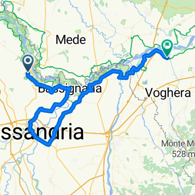
Pecetto and its Rocca form a short hilly variant of what is planned to become the VENTO route (the Venice-Turin cycle path).
After starting within Bosco Musolino (a beautiful example of restored nature on the outskirts of Valenza), the route continues gently along the Po River until Bassignana, with a mandatory stop on the riverbank at the Mugarone pier (a hamlet of Bassignana).
Returning to Borgata Pellizzari, you climb up to the village and the Rocca. From there the journey continues descending to the southern plain and returning to Valenza by a different route.
Traffic: with the exception of a short stretch between Mugarone and Pellizzari, it is generally manageable. Road surface: asphalt on the hilly section, mostly gravel road on the plain along the Po.
Valenza, Bosco Musolino – Torrente Grana – Regione Oche – Mugarone, pier on the Po – Bassignana – Mugarone – Pellizzari – Pecetto, Rocca – SP 79 – Strada Citerna – Valenza.
Train station in Valenza.
- -:--
- Duration
- 29 km
- Distance
- 308 m
- Ascent
- 306 m
- Descent
- ---
- Avg. speed
- 226 m
- Max. altitude

Route photos
\"")
\"")
\"")
\"")
\"")
\"")
Route quality
Waytypes & surfaces along the route
Waytypes
Quiet road
15.4 km
(53 %)
Track
6.7 km
(23 %)
Surfaces
Paved
17.7 km
(61 %)
Unpaved
4.3 km
(15 %)
Asphalt
15.4 km
(53 %)
Paved (undefined)
2.3 km
(8 %)
Route highlights
Points of interest along the route
\"")
Point of interest after 1.8 km
Bosco Musolino
\"")
Point of interest after 11 km
Pontile di Mugarone
Point of interest after 21.5 km
Rocca di Pecetto
Continue with Bikemap
Use, edit, or download this cycling route
You would like to ride Elogio della Rocca di Pecetto (e del pontile di Mugarone) or customize it for your own trip? Here is what you can do with this Bikemap route:
Free features
- Save this route as favorite or in collections
- Copy & plan your own version of this route
- Sync your route with Garmin or Wahoo
Premium features
Free trial for 3 days, or one-time payment. More about Bikemap Premium.
- Navigate this route on iOS & Android
- Export a GPX / KML file of this route
- Create your custom printout (try it for free)
- Download this route for offline navigation
Discover more Premium features.
Get Bikemap PremiumFrom our community
Other popular routes starting in Valenza
 Elogio della Rocca di Pecetto (e del pontile di Mugarone)
- Distance
- 29 km
- Ascent
- 308 m
- Descent
- 306 m
- Location
- Valenza, Piedmont, Italy
 valenza cella monte alessandria
- Distance
- 85.4 km
- Ascent
- 471 m
- Descent
- 493 m
- Location
- Valenza, Piedmont, Italy
 S.Salvatore Monferrato
- Distance
- 4.5 km
- Ascent
- 126 m
- Descent
- 0 m
- Location
- Valenza, Piedmont, Italy
 Valenza nach Trino
- Distance
- 47.9 km
- Ascent
- 98 m
- Descent
- 93 m
- Location
- Valenza, Piedmont, Italy
 Valenza / Venezia
- Distance
- 485.2 km
- Ascent
- 17 m
- Descent
- 148 m
- Location
- Valenza, Piedmont, Italy
 Monferrato 3a tappa - da Valenza ad Alessandria
- Distance
- 32.1 km
- Ascent
- 516 m
- Descent
- 535 m
- Location
- Valenza, Piedmont, Italy
 oche
oche- Distance
- 15.1 km
- Ascent
- 314 m
- Descent
- 313 m
- Location
- Valenza, Piedmont, Italy
 Valenza - Cervesina
- Distance
- 79.1 km
- Ascent
- 211 m
- Descent
- 254 m
- Location
- Valenza, Piedmont, Italy
Open it in the app