

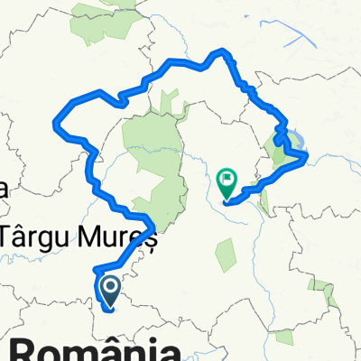
Colinele Transilvaniei: Sighișoara - Mănăstirea Sf. Dimitrie - Angofa - Platoul Breite - Sighișoara
A cycling route starting in Sighișoara, Mureș County, Romania.
Overview
About this route
An easy walk for hikers or cyclists, so you can admire the last truly medieval landscape in Europe.
Did you travel this route? If you have identified access problems (missing, damaged or insufficiently clear markings, inaccessible sections etc.) or have suggestions for their improvement, please write to us at transylvanianhighlands@gmail.com. Don't forget to take a GPS point and a few photos - it will help us to intervene faster to fix the situation.
- -:--
- Duration
- 17.5 km
- Distance
- 466 m
- Ascent
- 587 m
- Descent
- ---
- Avg. speed
- 660 m
- Max. altitude

Route quality
Waytypes & surfaces along the route
Waytypes
Track
8.2 km
(47 %)
Path
6.7 km
(38 %)
Surfaces
Paved
1.4 km
(8 %)
Unpaved
14.5 km
(83 %)
Ground
13.1 km
(75 %)
Asphalt
1.4 km
(8 %)
Continue with Bikemap
Use, edit, or download this cycling route
You would like to ride Colinele Transilvaniei: Sighișoara - Mănăstirea Sf. Dimitrie - Angofa - Platoul Breite - Sighișoara or customize it for your own trip? Here is what you can do with this Bikemap route:
Free features
- Save this route as favorite or in collections
- Copy & plan your own version of this route
- Sync your route with Garmin or Wahoo
Premium features
Free trial for 3 days, or one-time payment. More about Bikemap Premium.
- Navigate this route on iOS & Android
- Export a GPX / KML file of this route
- Create your custom printout (try it for free)
- Download this route for offline navigation
Discover more Premium features.
Get Bikemap PremiumFrom our community
Other popular routes starting in Sighișoara
 SZT / Segesvár - Szászkeresztúr
- Distance
- 32.2 km
- Ascent
- 454 m
- Descent
- 326 m
- Location
- Sighișoara, Mureș County, Romania
 Transilvania medievala 2016
- Distance
- 189.8 km
- Ascent
- 561 m
- Descent
- 585 m
- Location
- Sighișoara, Mureș County, Romania
 Vacanta 1 iunie - 5 iunie 2017
- Distance
- 465.3 km
- Ascent
- 2,550 m
- Descent
- 2,111 m
- Location
- Sighișoara, Mureș County, Romania
 ziua 1 Bunesti - Crit - Mesendorf - Saschiz - Sighisoara
- Distance
- 56.8 km
- Ascent
- 996 m
- Descent
- 853 m
- Location
- Sighișoara, Mureș County, Romania
 Aurel Vlaicu-saschiz -cloasterf
- Distance
- 44.9 km
- Ascent
- 812 m
- Descent
- 812 m
- Location
- Sighișoara, Mureș County, Romania
 SZT / Segesvar - Mese
- Distance
- 32.2 km
- Ascent
- 576 m
- Descent
- 363 m
- Location
- Sighișoara, Mureș County, Romania
 Szaszfoldi bejaras1
- Distance
- 61.9 km
- Ascent
- ---
- Descent
- ---
- Location
- Sighișoara, Mureș County, Romania
 Biertan
- Distance
- 60.7 km
- Ascent
- 365 m
- Descent
- 368 m
- Location
- Sighișoara, Mureș County, Romania
Open it in the app