

Colinele Transilvaniei: Circuit Mălâncrav - Hula Crișului - Dealul Sneal - Mălâncrav
A cycling route starting in Mălâncrav, Sibiu County, Romania.
Overview
About this route
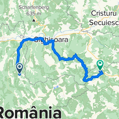
Leave the village going east towards Ciocârliei Hill. The road stars climbing gently amidst land plots, then more steeply on a hillcrest through the forest. Turn right on the hilltop (red cross marking), leave to your left the (blue strip) road taking you down to Criş and continue straight ahead on the hilltop going south, until you come across the old county road and the red strip marking. Follow the road to your right on the red strip marking on the watershed, first through the forest and then across the grassland (beautiful panorama of the village of Mălâncrav). Leave the road descending to Stejărișu to your left and shortly you will come across the road to Mălâncrav on your right. Take this road (red cross), go past an animal farm and enter Mălâncrav coming from the south.
Did you travel this route? If you have identified access problems (missing, damaged or insufficiently clear markings, inaccessible sections etc.) or have suggestions for their improvement, please write to us at transylvanianhighlands@gmail.com. Don't forget to take a GPS point and a few photos - it will help us to intervene faster to fix the situation.
- -:--
- Duration
- 18.2 km
- Distance
- 447 m
- Ascent
- 445 m
- Descent
- ---
- Avg. speed
- 650 m
- Max. altitude

Route quality
Waytypes & surfaces along the route
Waytypes
Path
15.3 km
(84 %)
Road
1.3 km
(7 %)
Surfaces
Paved
1.3 km
(7 %)
Unpaved
0.4 km
(2 %)
Asphalt
1.3 km
(7 %)
Unpaved (undefined)
0.4 km
(2 %)
Undefined
16.6 km
(91 %)
Continue with Bikemap
Use, edit, or download this cycling route
You would like to ride Colinele Transilvaniei: Circuit Mălâncrav - Hula Crișului - Dealul Sneal - Mălâncrav or customize it for your own trip? Here is what you can do with this Bikemap route:
Free features
- Save this route as favorite or in collections
- Copy & plan your own version of this route
- Sync your route with Garmin or Wahoo
Premium features
Free trial for 3 days, or one-time payment. More about Bikemap Premium.
- Navigate this route on iOS & Android
- Export a GPX / KML file of this route
- Create your custom printout (try it for free)
- Download this route for offline navigation
Discover more Premium features.
Get Bikemap PremiumFrom our community
Other popular routes starting in Mălâncrav
 Malancrav - Biertan - Richis
- Distance
- 30.3 km
- Ascent
- 560 m
- Descent
- 593 m
- Location
- Mălâncrav, Sibiu County, Romania
 Ziua 3 - Bisericile fortificate
- Distance
- 69 km
- Ascent
- 754 m
- Descent
- 716 m
- Location
- Mălâncrav, Sibiu County, Romania
 Colinele Transilvaniei: Circuit Mălâncrav - Hula Crișului - Dealul Sneal - Mălâncrav
- Distance
- 18.2 km
- Ascent
- 447 m
- Descent
- 445 m
- Location
- Mălâncrav, Sibiu County, Romania
 malancrav - culmea florestilor - floresti - laslea - roandola - nou sasesc - malancrav
- Distance
- 30.5 km
- Ascent
- 427 m
- Descent
- 460 m
- Location
- Mălâncrav, Sibiu County, Romania
 Criș - Stejăreni - Hula Crișului - Criș
- Distance
- 33.3 km
- Ascent
- 661 m
- Descent
- 662 m
- Location
- Mălâncrav, Sibiu County, Romania
 SZT - Keresd - rövid kör
- Distance
- 32.3 km
- Ascent
- 461 m
- Descent
- 462 m
- Location
- Mălâncrav, Sibiu County, Romania
 Coline 22 ZIua 3
- Distance
- 63.7 km
- Ascent
- 936 m
- Descent
- 889 m
- Location
- Mălâncrav, Sibiu County, Romania
 1. Circuit din Mălâncrav
- Distance
- 40.4 km
- Ascent
- 837 m
- Descent
- 837 m
- Location
- Mălâncrav, Sibiu County, Romania
Open it in the app