
Galor @ Bachok Kelantan
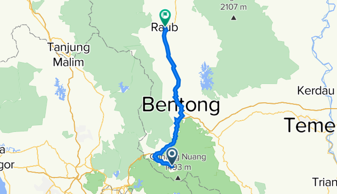
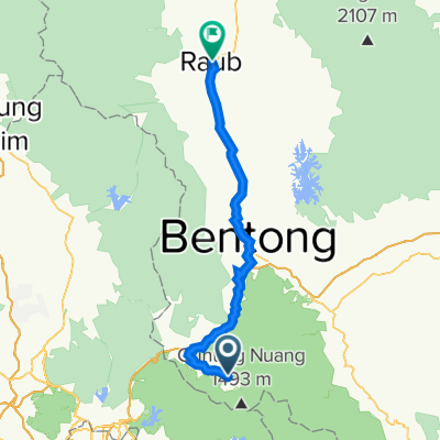
Day02 - Raub
A cycling route starting in Kampung Bukit Tinggi, Bentong, Pahang, Malaysia.
Overview
About this route
- -:--
- Duration
- 73.4 km
- Distance
- 1,151 m
- Ascent
- 1,464 m
- Descent
- ---
- Avg. speed
- 502 m
- Max. altitude

Part of

Galor @ Bachok Kelantan
4 stages
Route quality
Waytypes & surfaces along the route
Waytypes
Road
27.9 km
(38 %)
Quiet road
16.1 km
(22 %)
Surfaces
Paved
11.7 km
(16 %)
Unpaved
2.9 km
(4 %)
Asphalt
11.7 km
(16 %)
Unpaved (undefined)
2.9 km
(4 %)
Undefined
58.7 km
(80 %)
Continue with Bikemap
Use, edit, or download this cycling route
You would like to ride Day02 - Raub or customize it for your own trip? Here is what you can do with this Bikemap route:
Free features
- Save this route as favorite or in collections
- Copy & plan your own version of this route
- Sync your route with Garmin or Wahoo
Premium features
Free trial for 3 days, or one-time payment. More about Bikemap Premium.
- Navigate this route on iOS & Android
- Export a GPX / KML file of this route
- Create your custom printout (try it for free)
- Download this route for offline navigation
Discover more Premium features.
Get Bikemap PremiumFrom our community
Other popular routes starting in Kampung Bukit Tinggi
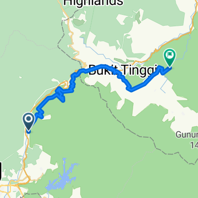 HOA-Janda Baik
- Distance
- 29.7 km
- Ascent
- 663 m
- Descent
- 402 m
- Location
- Kampung Bukit Tinggi, Bentong, Pahang, Malaysia
 Lengthy bike tour through Kuala Lumpur
- Distance
- 77.1 km
- Ascent
- 865 m
- Descent
- 937 m
- Location
- Kampung Bukit Tinggi, Bentong, Pahang, Malaysia
 Kampung Temiang,Lebuhraya Karak, Bentong to Jalan Sumsum Hilir, Bentong
- Distance
- 22.8 km
- Ascent
- 1,059 m
- Descent
- 775 m
- Location
- Kampung Bukit Tinggi, Bentong, Pahang, Malaysia
 Bentong Hot Spring to Chamang Waterfall
- Distance
- 53.3 km
- Ascent
- 456 m
- Descent
- 455 m
- Location
- Kampung Bukit Tinggi, Bentong, Pahang, Malaysia
 Japanese Garden, Bukit Tinggi
- Distance
- 1.5 km
- Ascent
- 314 m
- Descent
- 77 m
- Location
- Kampung Bukit Tinggi, Bentong, Pahang, Malaysia
 Day02 - Raub
- Distance
- 73.4 km
- Ascent
- 1,151 m
- Descent
- 1,464 m
- Location
- Kampung Bukit Tinggi, Bentong, Pahang, Malaysia
 Batu Gombak to Jalan Pesona P8
- Distance
- 22.1 km
- Ascent
- 532 m
- Descent
- 337 m
- Location
- Kampung Bukit Tinggi, Bentong, Pahang, Malaysia
 selesa GS waterfall
- Distance
- 21.2 km
- Ascent
- 1,326 m
- Descent
- 1,164 m
- Location
- Kampung Bukit Tinggi, Bentong, Pahang, Malaysia
Open it in the app