

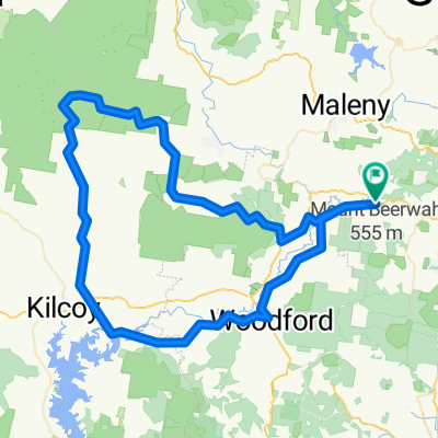
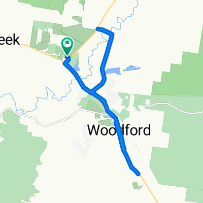
Archer camping area to The Gantry
A cycling route starting in Woodford, Queensland, Australia.
Overview
About this route
- -:--
- Duration
- 29.1 km
- Distance
- 1,140 m
- Ascent
- 1,142 m
- Descent
- ---
- Avg. speed
- 558 m
- Max. altitude

Route highlights
Points of interest along the route
Point of interest after 2.1 km
Neurum Break
Point of interest after 26.4 km
Neurum Break
Continue with Bikemap
Use, edit, or download this cycling route
You would like to ride Archer camping area to The Gantry or customize it for your own trip? Here is what you can do with this Bikemap route:
Free features
- Save this route as favorite or in collections
- Copy & plan your own version of this route
- Sync your route with Garmin or Wahoo
Premium features
Free trial for 3 days, or one-time payment. More about Bikemap Premium.
- Navigate this route on iOS & Android
- Export a GPX / KML file of this route
- Create your custom printout (try it for free)
- Download this route for offline navigation
Discover more Premium features.
Get Bikemap PremiumFrom our community
Other popular routes starting in Woodford
 16 Nov 2015, 11:52 AM
- Distance
- 32.8 km
- Ascent
- 386 m
- Descent
- 386 m
- Location
- Woodford, Queensland, Australia
 Moderate Route in Glass House Mountains
- Distance
- 6.1 km
- Ascent
- 13 m
- Descent
- 0 m
- Location
- Woodford, Queensland, Australia
 Einfache Fahrt in Cairns City
- Distance
- 1,846 km
- Ascent
- 5,400 m
- Descent
- 5,516 m
- Location
- Woodford, Queensland, Australia
 Mt Kilcoy Rd
- Distance
- 118.7 km
- Ascent
- 951 m
- Descent
- 950 m
- Location
- Woodford, Queensland, Australia
 Woodford-> conondale camping
- Distance
- 32.9 km
- Ascent
- 772 m
- Descent
- 768 m
- Location
- Woodford, Queensland, Australia
 Einfache Fahrt in Villeneuve
- Distance
- 18.2 km
- Ascent
- 98 m
- Descent
- 94 m
- Location
- Woodford, Queensland, Australia
 Jimna
Jimna- Distance
- 167.5 km
- Ascent
- 1,213 m
- Descent
- 1,226 m
- Location
- Woodford, Queensland, Australia
 25–31 Cruice Drive, Woodford to 25–31 Cruice Drive, Woodford
- Distance
- 17.7 km
- Ascent
- 115 m
- Descent
- 116 m
- Location
- Woodford, Queensland, Australia
Open it in the app