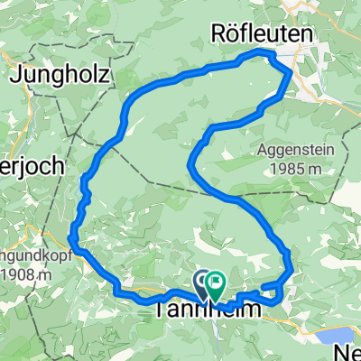
RSC TTal - Stuibenalpe
A cycling route starting in Tannheim, Tyrol, Austria.
Overview
About this route
25km / 790Hm
Pausen:
Stuben Sennalpe (km 12)
Stop auf dem Pass (km 21)
- -:--
- Duration
- 24.6 km
- Distance
- 1,415 m
- Ascent
- 1,415 m
- Descent
- ---
- Avg. speed
- 1,417 m
- Avg. speed
Route quality
Waytypes & surfaces along the route
Waytypes
Track
16.9 km
(69 %)
Quiet road
4.5 km
(18 %)
Surfaces
Paved
12.7 km
(52 %)
Unpaved
7.9 km
(32 %)
Gravel
7.9 km
(32 %)
Paved (undefined)
6.7 km
(27 %)
Continue with Bikemap
Use, edit, or download this cycling route
You would like to ride RSC TTal - Stuibenalpe or customize it for your own trip? Here is what you can do with this Bikemap route:
Free features
- Save this route as favorite or in collections
- Copy & plan your own version of this route
- Sync your route with Garmin or Wahoo
Premium features
Free trial for 3 days, or one-time payment. More about Bikemap Premium.
- Navigate this route on iOS & Android
- Export a GPX / KML file of this route
- Create your custom printout (try it for free)
- Download this route for offline navigation
Discover more Premium features.
Get Bikemap PremiumFrom our community
Other popular routes starting in Tannheim
- Tannheim-Nesselwaengle-Vilalbsee
- Distance
- 41.8 km
- Ascent
- 1,350 m
- Descent
- 1,350 m
- Location
- Tannheim, Tyrol, Austria
- Tannheim-Pronten-Reutte-Berwang-Namlos-Tannheim
- Distance
- 105 km
- Ascent
- 1,011 m
- Descent
- 1,012 m
- Location
- Tannheim, Tyrol, Austria
- Allgäu-Runde mittel
- Distance
- 124.3 km
- Ascent
- 820 m
- Descent
- 821 m
- Location
- Tannheim, Tyrol, Austria
- Tour Strinden Alpe
- Distance
- 23.7 km
- Ascent
- 948 m
- Descent
- 948 m
- Location
- Tannheim, Tyrol, Austria
- Tannheimer Tal - Radmarathon
- Distance
- 225.8 km
- Ascent
- 2,320 m
- Descent
- 2,321 m
- Location
- Tannheim, Tyrol, Austria
- Tour 2013 Namlosrunde Schwierigkeitsgrad mittel
- Distance
- 74.5 km
- Ascent
- 947 m
- Descent
- 951 m
- Location
- Tannheim, Tyrol, Austria
- Tour 2013 Auf König LudwigsSpuren mittel
- Distance
- 69.8 km
- Ascent
- 666 m
- Descent
- 666 m
- Location
- Tannheim, Tyrol, Austria
- Vorarlbergrunde
- Distance
- 166.2 km
- Ascent
- 2,190 m
- Descent
- 2,190 m
- Location
- Tannheim, Tyrol, Austria
Open it in the app