

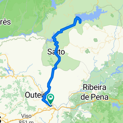
Tamega Trip
A cycling route starting in Cabeceiras de Basto, Braga District, Portugal.
Overview
About this route
- -:--
- Duration
- 52.6 km
- Distance
- 1,246 m
- Ascent
- 1,239 m
- Descent
- ---
- Avg. speed
- 348 m
- Max. altitude

Route highlights
Points of interest along the route
Accommodation after 0.3 km
Camping Arco
Accommodation after 3.2 km
Quinta Do Cascahal
Point of interest after 5.8 km
Quinta Dos Moinhos
Accommodation after 12.9 km
Quinta Do Rio
Point of interest after 15.9 km
Entry Point Tamega River
Point of interest after 27.9 km
Exit Point Tamega River
Continue with Bikemap
Use, edit, or download this cycling route
You would like to ride Tamega Trip or customize it for your own trip? Here is what you can do with this Bikemap route:
Free features
- Save this route as favorite or in collections
- Copy & plan your own version of this route
- Sync your route with Garmin or Wahoo
Premium features
Free trial for 3 days, or one-time payment. More about Bikemap Premium.
- Navigate this route on iOS & Android
- Export a GPX / KML file of this route
- Create your custom printout (try it for free)
- Download this route for offline navigation
Discover more Premium features.
Get Bikemap PremiumFrom our community
Other popular routes starting in Cabeceiras de Basto
 Tamega Trip
- Distance
- 52.6 km
- Ascent
- 1,246 m
- Descent
- 1,239 m
- Location
- Cabeceiras de Basto, Braga District, Portugal
 pisões
- Distance
- 100.5 km
- Ascent
- 1,267 m
- Descent
- 1,268 m
- Location
- Cabeceiras de Basto, Braga District, Portugal
 Fafe, Portugal
- Distance
- 49.5 km
- Ascent
- 811 m
- Descent
- 904 m
- Location
- Cabeceiras de Basto, Braga District, Portugal
 Moimenta - Sª Graça - Moimenta
- Distance
- 61.4 km
- Ascent
- 1,307 m
- Descent
- 1,303 m
- Location
- Cabeceiras de Basto, Braga District, Portugal
 Senhora Da Graca
- Distance
- 20 km
- Ascent
- 848 m
- Descent
- 185 m
- Location
- Cabeceiras de Basto, Braga District, Portugal
 Amarante - Arco de Baulhe
- Distance
- 39.1 km
- Ascent
- 314 m
- Descent
- 498 m
- Location
- Cabeceiras de Basto, Braga District, Portugal
 Treino rápido
- Distance
- 12.4 km
- Ascent
- 29 m
- Descent
- 0 m
- Location
- Cabeceiras de Basto, Braga District, Portugal
 Cabeceiras-Larouco-Cabeceiras
- Distance
- 148.7 km
- Ascent
- 2,053 m
- Descent
- 2,053 m
- Location
- Cabeceiras de Basto, Braga District, Portugal
Open it in the app