Donauradweg Serbien
A cycling route starting in Hercegsz谩nt贸, B谩cs-Kiskun county, Hungary.
Overview
About this route
- -:--
- Duration
- 664.2 km
- Distance
- 124 m
- Ascent
- 124 m
- Descent
- ---
- Avg. speed
- 111 m
- Max. altitude
Route quality
Waytypes & surfaces along the route
Waytypes
Quiet road
146.1 km
(22 %)
Road
106.3 km
(16 %)
Surfaces
Paved
458.3 km
(69 %)
Unpaved
46.5 km
(7 %)
Asphalt
445 km
(67 %)
Gravel
26.6 km
(4 %)
Continue with Bikemap
Use, edit, or download this cycling route
You would like to ride Donauradweg Serbien or customize it for your own trip? Here is what you can do with this Bikemap route:
Free features
- Save this route as favorite or in collections
- Copy & plan your own version of this route
- Split it into stages to create a multi-day tour
- Sync your route with Garmin or Wahoo
Premium features
Free trial for 3 days, or one-time payment. More about Bikemap Premium.
- Navigate this route on iOS & Android
- Export a GPX / KML file of this route
- Create your custom printout (try it for free)
- Download this route for offline navigation
Discover more Premium features.
Get Bikemap PremiumFrom our community
Other popular routes starting in Hercegsz谩nt贸
- 3.10 - II
- Distance
- 121.9 km
- Ascent
- 11 m
- Descent
- 26 m
- Location
- Hercegsz谩nt贸, B谩cs-Kiskun county, Hungary
- Donauradweg Serbien
- Distance
- 664.2 km
- Ascent
- 124 m
- Descent
- 124 m
- Location
- Hercegsz谩nt贸, B谩cs-Kiskun county, Hungary
- Ruta Hungary
- Distance
- 462.5 km
- Ascent
- 1,502 m
- Descent
- 1,505 m
- Location
- Hercegsz谩nt贸, B谩cs-Kiskun county, Hungary
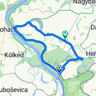
- Hercegszanto - Backi Monostor - Sombor
- Distance
- 35.4 km
- Ascent
- 21 m
- Descent
- 17 m
- Location
- Hercegsz谩nt贸, B谩cs-Kiskun county, Hungary
- 5151 26, Hercegsz谩nt贸 - Cs贸nak utca 12, Baja
- Distance
- 35.3 km
- Ascent
- 164 m
- Descent
- 216 m
- Location
- Hercegsz谩nt贸, B谩cs-Kiskun county, Hungary
- alternatief ujmohacs circle
- Distance
- 49.2 km
- Ascent
- 36 m
- Descent
- 37 m
- Location
- Hercegsz谩nt贸, B谩cs-Kiskun county, Hungary
- Tag 16: Von Hercegsz谩nt贸 nach Ko拧ut Lajosa, Batina
- Distance
- 15.5 km
- Ascent
- 217 m
- Descent
- 190 m
- Location
- Hercegsz谩nt贸, B谩cs-Kiskun county, Hungary
- mohacs
- Distance
- 50.4 km
- Ascent
- 44 m
- Descent
- 43 m
- Location
- Hercegsz谩nt贸, B谩cs-Kiskun county, Hungary
Open it in the app