

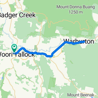
Woori Yallock - Mt Donna Buang Loop
A cycling route starting in Woori Yallock, Victoria, Australia.
Overview
About this route
Woori Yallock Bakery to summit of Mt Donna Buang avoiding the busy Warburton Hwy by using quieter back roads.
Up via Don Valley, Settlement Road and the Old Warburton Road pass (Mt Bride).
Go out of town up Riverside Drive before returning via the highway to Climb Mt Donna Buang.
Climb
Descend
Coffee stop in Warburton following the descent.
Take the highway home at first (Be warned there is no sealed shoulder, and a big drop-off at the edge of the asphalt onto the minimal gravel shoulder.)
OPTION FOR CLIMBERS: Return via Mt Bride Old warburton RoadPass
Turn south off the highway at Wesburn onto Railway Road.
Take Left at Lowes Rd
LEft onto Highway for short section.
Right onto Riversdale Road.
Turn right and Cross Yarra Junction - Noojee Rd then left into Milners Road
Climbover a spur before turning Right toward the highway on Launching Place and /Wickhams Rds.
Cross the highway and continue on Allsops Rd and then returning to the start point at the Bakery on Koo Wee Rup Rd Launching Place.
- -:--
- Duration
- 88.7 km
- Distance
- 1,640 m
- Ascent
- 1,646 m
- Descent
- ---
- Avg. speed
- ---
- Max. altitude

Route quality
Waytypes & surfaces along the route
Waytypes
Road
27.5 km
(31 %)
Quiet road
8 km
(9 %)
Surfaces
Paved
78.1 km
(88 %)
Unpaved
6.2 km
(7 %)
Asphalt
50.6 km
(57 %)
Paved (undefined)
27.5 km
(31 %)
Route highlights
Points of interest along the route
Point of interest after 66.6 km
Coffee stop
Continue with Bikemap
Use, edit, or download this cycling route
You would like to ride Woori Yallock - Mt Donna Buang Loop or customize it for your own trip? Here is what you can do with this Bikemap route:
Free features
- Save this route as favorite or in collections
- Copy & plan your own version of this route
- Split it into stages to create a multi-day tour
- Sync your route with Garmin or Wahoo
Premium features
Free trial for 3 days, or one-time payment. More about Bikemap Premium.
- Navigate this route on iOS & Android
- Export a GPX / KML file of this route
- Create your custom printout (try it for free)
- Download this route for offline navigation
Discover more Premium features.
Get Bikemap PremiumFrom our community
Other popular routes starting in Woori Yallock
 O'Shannassy Aqueduct Trail Loop via Launching Place and Woori Yallock
- Distance
- 19.3 km
- Ascent
- 425 m
- Descent
- 425 m
- Location
- Woori Yallock, Victoria, Australia
 Warburton Rail Trail
- Distance
- 36.4 km
- Ascent
- 119 m
- Descent
- 118 m
- Location
- Woori Yallock, Victoria, Australia
 Warburton Rail Trail 1934, Woori Yallock to Warburton Highway 2415C, Yarra Junction
- Distance
- 8.8 km
- Ascent
- 142 m
- Descent
- 117 m
- Location
- Woori Yallock, Victoria, Australia
 Woori Yallock to Warbuton
- Distance
- 17.1 km
- Ascent
- 139 m
- Descent
- 73 m
- Location
- Woori Yallock, Victoria, Australia
 1385A Healesville-Koo Wee Rup Road, Woori Yallock to 3394 Warburton Highway, Warburton
- Distance
- 16.7 km
- Ascent
- 115 m
- Descent
- 78 m
- Location
- Woori Yallock, Victoria, Australia
 Warburton Rail Trail, Launching Place to 3426 Warburton Highway, Warburton
- Distance
- 16.1 km
- Ascent
- 265 m
- Descent
- 172 m
- Location
- Woori Yallock, Victoria, Australia
 Warby Trail: Woori Yallock to Yarra Junction
- Distance
- 8.4 km
- Ascent
- 76 m
- Descent
- 49 m
- Location
- Woori Yallock, Victoria, Australia
 Piggery Hill
- Distance
- 1.2 km
- Ascent
- 69 m
- Descent
- 6 m
- Location
- Woori Yallock, Victoria, Australia
Open it in the app