Mórágyi erdőkerülő túra
- 31.7 km
- 395 m
- 395 m
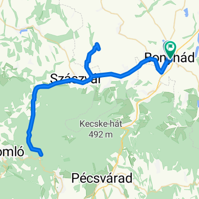
- Bonyhád, Tolna County, Hungary
A cycling route starting in Bonyhád, Tolna County, Hungary.
Overview
We started from Bonyhád, located at the north-eastern foothills of the Mecsek mountains. We rode on an asphalt, busy road at a good pace. The more serious climbs begin after Magyaregregy. Beautiful scenery, narrow, busy road, curves, climbs, descents. Varied terrain. Streams run alongside the road. At Hosszúhetény, a huge view from the hilltop. A long, enjoyable descent. Cycling is prohibited on main road 6. We cycle on the old main road 6. Near Mecseknádasd there is no alternative, you must get onto the main road. One must pay close attention. Winding, descending road, with heavy traffic. After a few hundred meters, we ride on side roads. After many sights, we return to the starting point.
created this 3 years ago
Route quality
Quiet road
10 km
(15 %)
Track
2.7 km
(4 %)
Paved
32 km
(48 %)
Unpaved
0.7 km
(1 %)
Asphalt
30.7 km
(46 %)
Concrete
1.3 km
(2 %)
Continue with Bikemap
You would like to ride Bonyhád - Mecsek aszfaltos bringatúra or customize it for your own trip? Here is what you can do with this Bikemap route:
Free trial for 3 days, or one-time payment. More about Bikemap Premium.
Discover more Premium features.
Get Bikemap PremiumFrom our community
Open it in the app