

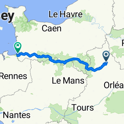
Chartres - Tours.
A cycling route starting in Chartres, Centre-Val de Loire, France.
Overview
About this route
- -:--
- Duration
- 173.1 km
- Distance
- 832 m
- Ascent
- 903 m
- Descent
- ---
- Avg. speed
- 168 m
- Max. altitude

Route quality
Waytypes & surfaces along the route
Waytypes
Road
61.3 km
(35 %)
Quiet road
55.5 km
(32 %)
Surfaces
Paved
70.3 km
(41 %)
Unpaved
3.3 km
(2 %)
Asphalt
69.3 km
(40 %)
Gravel
3.3 km
(2 %)
Route highlights
Points of interest along the route
Point of interest after 8.1 km
Abbaye cistercienne de l'Eau
Point of interest after 18.4 km
Eglise Saint Orien
Point of interest after 29.9 km
Eglise Saint Chéron
Point of interest after 47.2 km
Eglise Saint Christophe
Point of interest after 54.4 km
Camping municipale
Point of interest after 64 km
Eglise Saint Hilaire
Point of interest after 66.7 km
Chateau
Point of interest after 84.8 km
Kerk
Point of interest after 85.1 km
Auberge
Point of interest after 91.8 km
Eglise
Point of interest after 103 km
Kapel Saint Jacques
Point of interest after 110.9 km
Eglise Saint-Pierre
Point of interest after 122.7 km
Eglise Saint Baptiste
Point of interest after 133.3 km
Camping municipale
Point of interest after 143.5 km
Auberge de la Brenne
Continue with Bikemap
Use, edit, or download this cycling route
You would like to ride Chartres - Tours. or customize it for your own trip? Here is what you can do with this Bikemap route:
Free features
- Save this route as favorite or in collections
- Copy & plan your own version of this route
- Split it into stages to create a multi-day tour
- Sync your route with Garmin or Wahoo
Premium features
Free trial for 3 days, or one-time payment. More about Bikemap Premium.
- Navigate this route on iOS & Android
- Export a GPX / KML file of this route
- Create your custom printout (try it for free)
- Download this route for offline navigation
Discover more Premium features.
Get Bikemap PremiumFrom our community
Other popular routes starting in Chartres
 Comp-D10b-Chartr-S-J-Froid-80km
- Distance
- 79.5 km
- Ascent
- 230 m
- Descent
- 385 m
- Location
- Chartres, Centre-Val de Loire, France
 Crisp ride in
- Distance
- 29.1 km
- Ascent
- 463 m
- Descent
- 462 m
- Location
- Chartres, Centre-Val de Loire, France
 Velocenie août 2025
- Distance
- 319.3 km
- Ascent
- 1,872 m
- Descent
- 2,023 m
- Location
- Chartres, Centre-Val de Loire, France
 Comp-D10-Chartr-Chateau-58km
- Distance
- 58.1 km
- Ascent
- 250 m
- Descent
- 266 m
- Location
- Chartres, Centre-Val de Loire, France
 chartres Erdeven owlcamp
- Distance
- 459.5 km
- Ascent
- 402 m
- Descent
- 541 m
- Location
- Chartres, Centre-Val de Loire, France
 D1 Chartres-Vasselay
- Distance
- 202.6 km
- Ascent
- 309 m
- Descent
- 277 m
- Location
- Chartres, Centre-Val de Loire, France
 EU 17 _ Chartres - Chateaudun _ 67 km
- Distance
- 67.2 km
- Ascent
- 104 m
- Descent
- 145 m
- Location
- Chartres, Centre-Val de Loire, France
 chartres erdeven via le mans
- Distance
- 422.6 km
- Ascent
- 508 m
- Descent
- 634 m
- Location
- Chartres, Centre-Val de Loire, France
Open it in the app