Triathlon Sprint Gorizia 2011
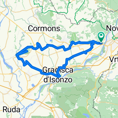
A cycling route starting in Gorizia, Friuli Venezia Giulia, Italy.
Overview
About this route
The cycling route unfolds on a single loop crossing the municipality of Savogna d'Isonzo, the locality of Peteano, the climb (2.5 km) of Monte San Michele, the locality of S. Michele, descent towards the locality of Gabria and re-crossing the municipality of Savogna d'Isonzo until the transition zone of Campagnuzza. WARNING:
In Savogna d'Isonzo, a short detour is marked due to ongoing road works.
- -:--
- Duration
- 20.7 km
- Distance
- 266 m
- Ascent
- 267 m
- Descent
- ---
- Avg. speed
- ---
- Max. altitude
Route quality
Waytypes & surfaces along the route
Waytypes
Quiet road
6.2 km
(30 %)
Road
4.8 km
(23 %)
Surfaces
Paved
14.9 km
(72 %)
Asphalt
14.9 km
(72 %)
Undefined
5.8 km
(28 %)
Route highlights
Points of interest along the route
Drinking water after 4.3 km
Deviazione per lavori in corso segnalata
Continue with Bikemap
Use, edit, or download this cycling route
You would like to ride Triathlon Sprint Gorizia 2011 or customize it for your own trip? Here is what you can do with this Bikemap route:
Free features
- Save this route as favorite or in collections
- Copy & plan your own version of this route
- Sync your route with Garmin or Wahoo
Premium features
Free trial for 3 days, or one-time payment. More about Bikemap Premium.
- Navigate this route on iOS & Android
- Export a GPX / KML file of this route
- Create your custom printout (try it for free)
- Download this route for offline navigation
Discover more Premium features.
Get Bikemap PremiumFrom our community
Other popular routes starting in Gorizia
 Colle di Medea
- Distance
- 44.9 km
- Ascent
- 218 m
- Descent
- 218 m
- Location
- Gorizia, Friuli Venezia Giulia, Italy
 Giro bici Trikids e Minitriathlon
- Distance
- 1 km
- Ascent
- 9 m
- Descent
- 9 m
- Location
- Gorizia, Friuli Venezia Giulia, Italy
 GorizianINbici - Collio e Brda al chiaror di luna 2018
- Distance
- 32.2 km
- Ascent
- 520 m
- Descent
- 520 m
- Location
- Gorizia, Friuli Venezia Giulia, Italy
 Collio - Brda
- Distance
- 42.7 km
- Ascent
- 813 m
- Descent
- 813 m
- Location
- Gorizia, Friuli Venezia Giulia, Italy
 Slowenien Etappe 1 - 3
- Distance
- 270.3 km
- Ascent
- 3,270 m
- Descent
- 3,114 m
- Location
- Gorizia, Friuli Venezia Giulia, Italy
 isontinoinbici.it - Monte Calvario e Collio
- Distance
- 22.2 km
- Ascent
- 420 m
- Descent
- 419 m
- Location
- Gorizia, Friuli Venezia Giulia, Italy
 Pedemontana friulana e veneta
- Distance
- 293.9 km
- Ascent
- 925 m
- Descent
- 925 m
- Location
- Gorizia, Friuli Venezia Giulia, Italy
 Triathlon Sprint Gorizia 2011
- Distance
- 20.7 km
- Ascent
- 266 m
- Descent
- 267 m
- Location
- Gorizia, Friuli Venezia Giulia, Italy
Open it in the app

