

CYCLING THE RHINE: Route 10A
A cycling route starting in Altstadt Nord, North Rhine-Westphalia, Germany.
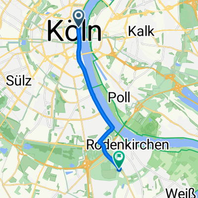
Overview
About this route
From Cologne (Koln) railway station to Linz am Rhein railway station, following the Rhine. Right bank from Cologne to Bonn, then Left bank from Bonn to Linz am Rhein.
Or cross from Right bank at Lulsdorf to Wesseling, then on to Bonn along the Left bank. Alternate route on Left bank between Cologne and Bonn: CYCLING THE RHINE: Route 10A.alt- -:--
- Duration
- 65.9 km
- Distance
- 147 m
- Ascent
- 138 m
- Descent
- ---
- Avg. speed
- ---
- Max. altitude
Route quality
Waytypes & surfaces along the route
Waytypes
Path
36 km
(55 %)
Pedestrian area
7.2 km
(11 %)
Surfaces
Paved
61.4 km
(93 %)
Unpaved
1.8 km
(3 %)
Asphalt
42.3 km
(64 %)
Paving stones
16.2 km
(25 %)
Route highlights
Points of interest along the route
Accommodation after 0.9 km
Hostelling International, DJH Koln-Riehl. This marker position not exact: address is An der Schanz 14, 50735 Koln.
Point of interest after 0.9 km
STEPS. To avoid the steps, continue straight onwards, then turn Right and Right again directly towards the Rhine.
Accommodation after 0.9 km
Hostelling International, DJH Koln-Deutz. Siegestrasse 5, 50679 Koln.
Accommodation after 8.3 km
I have camped at this site on a number of occasions and always found the facilities and service to be exceptionally good.
Point of interest after 20.5 km
FERRY: Wesseling - Lulsdorf
Point of interest after 22.1 km
FERRY: Lulsdorf - Wesseling
Point of interest after 32.4 km
Ferry
Point of interest after 32.5 km
Ferry
Point of interest after 33.5 km
CAUTION: sharp LEFT turn
Point of interest after 35.7 km
Carry on straight along and under the motorway, to take the FERRY across the Sieg River.
Point of interest after 36.1 km
FERRY: Sieg River
Point of interest after 40.5 km
Route from Cologne (Koln) to Bonn along Left bank of the Rhine, joins described route here.
Accommodation after 41.8 km
Hostelling International, DJH Bonn. Haager Weg 42, 53127 Bonn.
Point of interest after 52.9 km
Border between the States (Lander) of Nordrhein-Westfalen and Rheinland-Pfalz
Accommodation after 54.6 km
Hostelling International, DJH Bad Honnef. Selhofer Strasse 106, 53604 Bad Honnef.
Point of interest after 61.9 km
Remagen Peace Bridge Museum.
Point of interest after 64.9 km
At this point, this route deviates from the Rhine Route, to terminate at Linz railway station. The Rhine Route continues from here, on this side of the river (Left bank), all the way to Koblenz.
Continue with Bikemap
Use, edit, or download this cycling route
You would like to ride CYCLING THE RHINE: Route 10A or customize it for your own trip? Here is what you can do with this Bikemap route:
Free features
- Save this route as favorite or in collections
- Copy & plan your own version of this route
- Sync your route with Garmin or Wahoo
Premium features
Free trial for 3 days, or one-time payment. More about Bikemap Premium.
- Navigate this route on iOS & Android
- Export a GPX / KML file of this route
- Create your custom printout (try it for free)
- Download this route for offline navigation
Discover more Premium features.
Get Bikemap PremiumFrom our community
Other popular routes starting in Altstadt Nord
 Im rechtsrheinischen Grüngürtel
- Distance
- 30.8 km
- Ascent
- 77 m
- Descent
- 67 m
- Location
- Altstadt Nord, North Rhine-Westphalia, Germany
 Leichlingen Radtour
- Distance
- 62.3 km
- Ascent
- 172 m
- Descent
- 176 m
- Location
- Altstadt Nord, North Rhine-Westphalia, Germany
 CYCLING THE RHINE: Route R11A
- Distance
- 59.2 km
- Ascent
- 97 m
- Descent
- 108 m
- Location
- Altstadt Nord, North Rhine-Westphalia, Germany
 Forstbotanischer Garten, Köln
- Distance
- 7.5 km
- Ascent
- 41 m
- Descent
- 34 m
- Location
- Altstadt Nord, North Rhine-Westphalia, Germany
 Köln - Koblenz
- Distance
- 95.1 km
- Ascent
- 123 m
- Descent
- 104 m
- Location
- Altstadt Nord, North Rhine-Westphalia, Germany
 Marienfeld / Papsthügel
- Distance
- 56.6 km
- Ascent
- 190 m
- Descent
- 185 m
- Location
- Altstadt Nord, North Rhine-Westphalia, Germany
 Königsdorf
- Distance
- 35.2 km
- Ascent
- 82 m
- Descent
- 71 m
- Location
- Altstadt Nord, North Rhine-Westphalia, Germany
 CYCLING THE RHINE: Route 10A
- Distance
- 65.9 km
- Ascent
- 147 m
- Descent
- 138 m
- Location
- Altstadt Nord, North Rhine-Westphalia, Germany
Open it in the app