

Keon Park to Federation Square
A cycling route starting in Thomastown, Victoria, Australia.
Overview
About this route
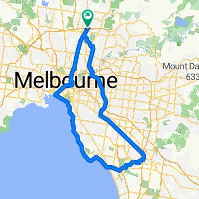
This route starts in Keon Park and mostly follows the Darebin Creek Trail into the city.
- -:--
- Duration
- 31.6 km
- Distance
- 111 m
- Ascent
- 200 m
- Descent
- ---
- Avg. speed
- 113 m
- Max. altitude
Route quality
Waytypes & surfaces along the route
Waytypes
Cycleway
23.9 km
(76 %)
Quiet road
4.4 km
(14 %)
Surfaces
Paved
31.2 km
(99 %)
Unpaved
0.2 km
(<1 %)
Concrete
19.1 km
(61 %)
Asphalt
10.7 km
(34 %)
Continue with Bikemap
Use, edit, or download this cycling route
You would like to ride Keon Park to Federation Square or customize it for your own trip? Here is what you can do with this Bikemap route:
Free features
- Save this route as favorite or in collections
- Copy & plan your own version of this route
- Sync your route with Garmin or Wahoo
Premium features
Free trial for 3 days, or one-time payment. More about Bikemap Premium.
- Navigate this route on iOS & Android
- Export a GPX / KML file of this route
- Create your custom printout (try it for free)
- Download this route for offline navigation
Discover more Premium features.
Get Bikemap PremiumFrom our community
Other popular routes starting in Thomastown
 longer one
- Distance
- 37.2 km
- Ascent
- 198 m
- Descent
- 197 m
- Location
- Thomastown, Victoria, Australia
 51 Messmate Street, Lalor to 285 Holt Parade, Thomastown
- Distance
- 3.4 km
- Ascent
- 6 m
- Descent
- 16 m
- Location
- Thomastown, Victoria, Australia
 92 kn Challenge
- Distance
- 92.3 km
- Ascent
- 330 m
- Descent
- 330 m
- Location
- Thomastown, Victoria, Australia
 Keon Park to Federation Square
- Distance
- 31.6 km
- Ascent
- 111 m
- Descent
- 200 m
- Location
- Thomastown, Victoria, Australia
 Dalton Road 69B, Thomastown to Dalton Road 40A, Thomastown
- Distance
- 110.4 km
- Ascent
- 479 m
- Descent
- 479 m
- Location
- Thomastown, Victoria, Australia
 100ish
- Distance
- 99.1 km
- Ascent
- 185 m
- Descent
- 185 m
- Location
- Thomastown, Victoria, Australia
 Murchison Way 32, Thomastown to Murchison Way 32, Thomastown
- Distance
- 32.5 km
- Ascent
- 169 m
- Descent
- 172 m
- Location
- Thomastown, Victoria, Australia
 6A Tuscan Ct, Thomastown to 27 Binnak Dr, Watsonia North
- Distance
- 9.8 km
- Ascent
- 124 m
- Descent
- 136 m
- Location
- Thomastown, Victoria, Australia
Open it in the app