

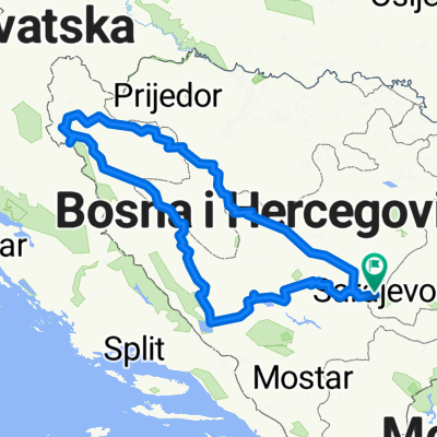
Sarajevo Fojnica Prokosko jezero Novi Travnik
A cycling route starting in Sarajevo, Federation of Bosnia and Herzegovina, Bosnia and Herzegovina.
Overview
About this route
Sarajevo Fojnica Prokosko jezero Novi Travnik
- -:--
- Duration
- 177.3 km
- Distance
- 4,063 m
- Ascent
- 4,047 m
- Descent
- ---
- Avg. speed
- 1,696 m
- Max. altitude

Route quality
Waytypes & surfaces along the route
Waytypes
Quiet road
39 km
(22 %)
Road
35.5 km
(20 %)
Surfaces
Paved
120.6 km
(68 %)
Unpaved
42.6 km
(24 %)
Asphalt
120.6 km
(68 %)
Gravel
31.9 km
(18 %)
Continue with Bikemap
Use, edit, or download this cycling route
You would like to ride Sarajevo Fojnica Prokosko jezero Novi Travnik or customize it for your own trip? Here is what you can do with this Bikemap route:
Free features
- Save this route as favorite or in collections
- Copy & plan your own version of this route
- Split it into stages to create a multi-day tour
- Sync your route with Garmin or Wahoo
Premium features
Free trial for 3 days, or one-time payment. More about Bikemap Premium.
- Navigate this route on iOS & Android
- Export a GPX / KML file of this route
- Create your custom printout (try it for free)
- Download this route for offline navigation
Discover more Premium features.
Get Bikemap PremiumFrom our community
Other popular routes starting in Sarajevo
 Voyage de malade
- Distance
- 1,793.6 km
- Ascent
- 2,905 m
- Descent
- 3,212 m
- Location
- Sarajevo, Federation of Bosnia and Herzegovina, Bosnia and Herzegovina
 Alipasino - Barice (hardway)
- Distance
- 12.1 km
- Ascent
- 545 m
- Descent
- 63 m
- Location
- Sarajevo, Federation of Bosnia and Herzegovina, Bosnia and Herzegovina
 From Sarajevo to Visoko
- Distance
- 55.3 km
- Ascent
- 1,350 m
- Descent
- 1,441 m
- Location
- Sarajevo, Federation of Bosnia and Herzegovina, Bosnia and Herzegovina
 ilidza - hum
- Distance
- 28.1 km
- Ascent
- 413 m
- Descent
- 414 m
- Location
- Sarajevo, Federation of Bosnia and Herzegovina, Bosnia and Herzegovina
 vrelo Bosne
- Distance
- 7.1 km
- Ascent
- 102 m
- Descent
- 57 m
- Location
- Sarajevo, Federation of Bosnia and Herzegovina, Bosnia and Herzegovina
 lukavica>tvrdimići>jasik&>brus>bistrik kula
- Distance
- 45.3 km
- Ascent
- 1,519 m
- Descent
- 1,517 m
- Location
- Sarajevo, Federation of Bosnia and Herzegovina, Bosnia and Herzegovina
 first alternative Sarajevo-milano
- Distance
- 1,264.6 km
- Ascent
- 2,281 m
- Descent
- 2,685 m
- Location
- Sarajevo, Federation of Bosnia and Herzegovina, Bosnia and Herzegovina
 Giro di West Bosnia
- Distance
- 797.6 km
- Ascent
- 19,774 m
- Descent
- 19,773 m
- Location
- Sarajevo, Federation of Bosnia and Herzegovina, Bosnia and Herzegovina
Open it in the app