final itinerary august ´18
- 885.2 km
- 3,327 m
- 3,874 m
- Sarajevo, Federation of Bosnia and Herzegovina, Bosnia and Herzegovina
A cycling route starting in Sarajevo, Federation of Bosnia and Herzegovina, Bosnia and Herzegovina.
Overview
created this 3 years ago
Route quality
Quiet road
236.6 km
(18 %)
Track
223.5 km
(17 %)
Paved
723 km
(55 %)
Unpaved
131.5 km
(10 %)
Asphalt
683.6 km
(52 %)
Ground
92 km
(7 %)
Route highlights

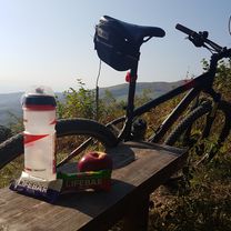
Starting line
camping
camping

A regular city in the Balkans...

Ciro Trail : a cyclist dream

Some James Bond shit
Very scenic route

Switchbacks for the win

River and mountains
Most beautiful bed and breakfast place in the world.
Komani Lake ferry
Camped in the park

Gjakova

Ottomans culture is part of the landscape
Found a hostal and a small restaurant

National park Mavrovo

Mont Korab

Debar

Ohrid

Trpejca

Florina

Arnissa

Naousa

Thessaloniki
Continue with Bikemap
You would like to ride The Balkan Backlands : 7 countries through the mountains or customize it for your own trip? Here is what you can do with this Bikemap route:
Free trial for 3 days, or one-time payment. More about Bikemap Premium.
Discover more Premium features.
Get Bikemap PremiumFrom our community
Open it in the app