

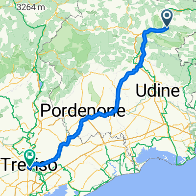
Chiusaforte-Torn-Maglern-Chiusaforte
A cycling route starting in Chiusaforte, Friuli Venezia Giulia, Italy.
Overview
About this route
The route almost always follows the new FVG1 cycle path, built on the route of the disused railway; the route is not shown on the map but the itinerary follows it faithfully. In the first section (Chiusaforte-Pontebba) there is quite a bit of climbing due to the constant gradient of the railway line, which you only notice on the return trip when you descend very quickly.
Many points of this section pass through tunnels, sometimes short and lit, sometimes long and completely dark (hopefully not forever). The route also crosses two very high bridges, which offer unique views.
The next part, up to the Camporosso pass, is less demanding and offers natural landscapes that can be appreciated in absolute silence, crossing wide clearings in the valley floor.
The last part, from Camporosso to Torn-Maglern, is almost always downhill, except for a couple of ramps (which break the monotony) near Coccau.
- -:--
- Duration
- 91.8 km
- Distance
- 820 m
- Ascent
- 820 m
- Descent
- ---
- Avg. speed
- ---
- Max. altitude
Route highlights
Points of interest along the route
Point of interest after 3.8 km
Ponte della ferrovia che da sull'abitato di Dogna
Point of interest after 6.5 km
Ponte ferroviario con vista panoramica
Continue with Bikemap
Use, edit, or download this cycling route
You would like to ride Chiusaforte-Torn-Maglern-Chiusaforte or customize it for your own trip? Here is what you can do with this Bikemap route:
Free features
- Save this route as favorite or in collections
- Copy & plan your own version of this route
- Split it into stages to create a multi-day tour
- Sync your route with Garmin or Wahoo
Premium features
Free trial for 3 days, or one-time payment. More about Bikemap Premium.
- Navigate this route on iOS & Android
- Export a GPX / KML file of this route
- Create your custom printout (try it for free)
- Download this route for offline navigation
Discover more Premium features.
Get Bikemap PremiumFrom our community
Other popular routes starting in Chiusaforte
 Ciclovia Alpe Adria (tratta da Chiusaforte a Valbruna)
- Distance
- 30.7 km
- Ascent
- 532 m
- Descent
- 142 m
- Location
- Chiusaforte, Friuli Venezia Giulia, Italy
 Venzone - Udine
- Distance
- 82.8 km
- Ascent
- 869 m
- Descent
- 1,145 m
- Location
- Chiusaforte, Friuli Venezia Giulia, Italy
 Pecol-Nasfeld KochahMautern-TreCroci-Paularo-Zermula-Ponteba- Nevea.Pecol
- Distance
- 196 km
- Ascent
- 4,135 m
- Descent
- 4,130 m
- Location
- Chiusaforte, Friuli Venezia Giulia, Italy
 Chiusaforte a Via Roma 23, Venzone
- Distance
- 24.8 km
- Ascent
- 325 m
- Descent
- 524 m
- Location
- Chiusaforte, Friuli Venezia Giulia, Italy
 Chiusaforte - Azzano Decimo
- Distance
- 159.4 km
- Ascent
- 665 m
- Descent
- 1,046 m
- Location
- Chiusaforte, Friuli Venezia Giulia, Italy
 Da Via Stazione a Bahnhofstraße
- Distance
- 67.5 km
- Ascent
- 1,208 m
- Descent
- 1,113 m
- Location
- Chiusaforte, Friuli Venezia Giulia, Italy
 Runde Sella Nevea Tarvis Kanaltal
- Distance
- 74.7 km
- Ascent
- 961 m
- Descent
- 961 m
- Location
- Chiusaforte, Friuli Venezia Giulia, Italy
 Val Aupa - Sella Cereschiatis 54
- Distance
- 50.7 km
- Ascent
- 1,827 m
- Descent
- 1,824 m
- Location
- Chiusaforte, Friuli Venezia Giulia, Italy
Open it in the app