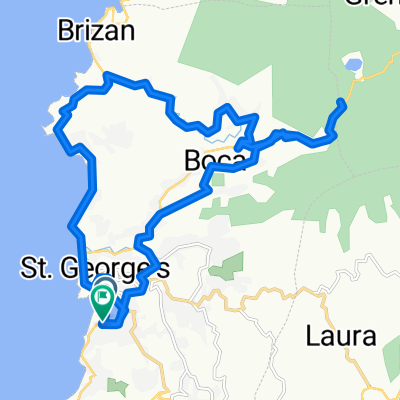
Recovered Route
A cycling route starting in St. George's, Saint George Parish, Grenada.
Overview
About this route
- 4 h 2 min
- Duration
- 47.6 km
- Distance
- 1,117 m
- Ascent
- 1,085 m
- Descent
- 11.8 km/h
- Avg. speed
- ---
- Max. altitude
Route photos
Route quality
Waytypes & surfaces along the route
Waytypes
Road
7.1 km
(15 %)
Quiet road
2.9 km
(6 %)
Surfaces
Paved
36.2 km
(76 %)
Asphalt
35.2 km
(74 %)
Concrete
1 km
(2 %)
Undefined
11.4 km
(24 %)
Continue with Bikemap
Use, edit, or download this cycling route
You would like to ride Recovered Route or customize it for your own trip? Here is what you can do with this Bikemap route:
Free features
- Save this route as favorite or in collections
- Copy & plan your own version of this route
- Sync your route with Garmin or Wahoo
Premium features
Free trial for 3 days, or one-time payment. More about Bikemap Premium.
- Navigate this route on iOS & Android
- Export a GPX / KML file of this route
- Create your custom printout (try it for free)
- Download this route for offline navigation
Discover more Premium features.
Get Bikemap PremiumFrom our community
Other popular routes starting in St. George's
- Sugar Mill - Thebaide Hill - Vincennes - St Pauls - St Georges - Sugar Mill
- Distance
- 35.7 km
- Ascent
- 627 m
- Descent
- 627 m
- Location
- St. George's, Saint George Parish, Grenada
- Annandale mountain bike circuit
- Distance
- 4.9 km
- Ascent
- 192 m
- Descent
- 189 m
- Location
- St. George's, Saint George Parish, Grenada
- Port Louis Marina - Morne Jaloux Ridge - Wobburn and return via Springs
- Distance
- 14.1 km
- Ascent
- 373 m
- Descent
- 370 m
- Location
- St. George's, Saint George Parish, Grenada
- Grenada Round 2
- Distance
- 43 km
- Ascent
- 541 m
- Descent
- 543 m
- Location
- St. George's, Saint George Parish, Grenada
- Grand Anse circuit - very steep climbs
- Distance
- 14.5 km
- Ascent
- 469 m
- Descent
- 456 m
- Location
- St. George's, Saint George Parish, Grenada
- Recovered Route
- Distance
- 47.6 km
- Ascent
- 1,117 m
- Descent
- 1,085 m
- Location
- St. George's, Saint George Parish, Grenada
- Oyster Regatta course B
- Distance
- 32.6 km
- Ascent
- 0 m
- Descent
- 0 m
- Location
- St. George's, Saint George Parish, Grenada
- St Georges to Grand Etang, return via Belvedere, Clozier, Gouyave
- Distance
- 44.7 km
- Ascent
- 1,485 m
- Descent
- 1,472 m
- Location
- St. George's, Saint George Parish, Grenada
Open it in the app