

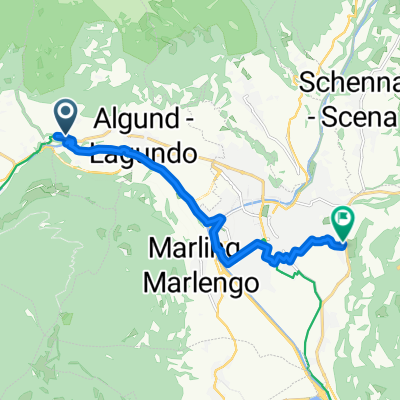
Leiteralm ab Algund
A cycling route starting in Algund, Trentino-Alto Adige, Italy.
Overview
About this route
- -:--
- Duration
- 12.7 km
- Distance
- 1,198 m
- Ascent
- 24 m
- Descent
- ---
- Avg. speed
- 1,525 m
- Max. altitude

Route quality
Waytypes & surfaces along the route
Waytypes
Quiet road
6.7 km
(53 %)
Track
2.2 km
(17 %)
Surfaces
Paved
8.4 km
(66 %)
Unpaved
1 km
(8 %)
Asphalt
7.2 km
(57 %)
Paved (undefined)
1.1 km
(9 %)
Continue with Bikemap
Use, edit, or download this cycling route
You would like to ride Leiteralm ab Algund or customize it for your own trip? Here is what you can do with this Bikemap route:
Free features
- Save this route as favorite or in collections
- Copy & plan your own version of this route
- Sync your route with Garmin or Wahoo
Premium features
Free trial for 3 days, or one-time payment. More about Bikemap Premium.
- Navigate this route on iOS & Android
- Export a GPX / KML file of this route
- Create your custom printout (try it for free)
- Download this route for offline navigation
Discover more Premium features.
Get Bikemap PremiumFrom our community
Other popular routes starting in Algund
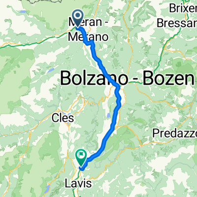 Meran - San Michele all'Adige
- Distance
- 71.2 km
- Ascent
- 236 m
- Descent
- 422 m
- Location
- Algund, Trentino-Alto Adige, Italy
 Algund Falzeben 2
- Distance
- 19.7 km
- Ascent
- 1,355 m
- Descent
- 27 m
- Location
- Algund, Trentino-Alto Adige, Italy
 Bergtour über Gampenjoch und Meldelpass
- Distance
- 102.7 km
- Ascent
- 1,751 m
- Descent
- 1,751 m
- Location
- Algund, Trentino-Alto Adige, Italy
 Route zu P1 Schloss Trauttmansdorff - P1 Castel Trauttmansdorff
- Distance
- 11.1 km
- Ascent
- 108 m
- Descent
- 261 m
- Location
- Algund, Trentino-Alto Adige, Italy
 Algunder Runde
- Distance
- 26.2 km
- Ascent
- 1,256 m
- Descent
- 1,255 m
- Location
- Algund, Trentino-Alto Adige, Italy
 Thalguter-1
- Distance
- 29.2 km
- Ascent
- 1,411 m
- Descent
- 82 m
- Location
- Algund, Trentino-Alto Adige, Italy
 Algund - Schloss Tirol - Muthöfe
- Distance
- 13.4 km
- Ascent
- 1,099 m
- Descent
- 127 m
- Location
- Algund, Trentino-Alto Adige, Italy
 Gasthof Brünnl
- Distance
- 9.5 km
- Ascent
- 434 m
- Descent
- 2 m
- Location
- Algund, Trentino-Alto Adige, Italy
Open it in the app