

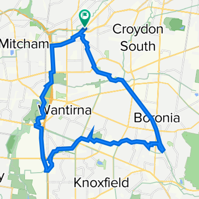
Ringwood Station > Flinders St Station
A cycling route starting in Ringwood East, Victoria, Australia.
Overview
About this route
- -:--
- Duration
- 33.8 km
- Distance
- 226 m
- Ascent
- 338 m
- Descent
- ---
- Avg. speed
- 152 m
- Max. altitude

Route quality
Waytypes & surfaces along the route
Waytypes
Cycleway
30.4 km
(90 %)
Quiet road
2.4 km
(7 %)
Surfaces
Paved
29.8 km
(88 %)
Unpaved
1 km
(3 %)
Asphalt
15.6 km
(46 %)
Concrete
12.2 km
(36 %)
Continue with Bikemap
Use, edit, or download this cycling route
You would like to ride Ringwood Station > Flinders St Station or customize it for your own trip? Here is what you can do with this Bikemap route:
Free features
- Save this route as favorite or in collections
- Copy & plan your own version of this route
- Sync your route with Garmin or Wahoo
Premium features
Free trial for 3 days, or one-time payment. More about Bikemap Premium.
- Navigate this route on iOS & Android
- Export a GPX / KML file of this route
- Create your custom printout (try it for free)
- Download this route for offline navigation
Discover more Premium features.
Get Bikemap PremiumFrom our community
Other popular routes starting in Ringwood East
 Costco via Blackburn Lake
- Distance
- 16.3 km
- Ascent
- 143 m
- Descent
- 179 m
- Location
- Ringwood East, Victoria, Australia
 Ringwood > Kew V2
- Distance
- 70.4 km
- Ascent
- 508 m
- Descent
- 509 m
- Location
- Ringwood East, Victoria, Australia
 Ringwood to Yarra Glen, Death Valley and return
- Distance
- 83.7 km
- Ascent
- 497 m
- Descent
- 494 m
- Location
- Ringwood East, Victoria, Australia
 morning ride
- Distance
- 30.2 km
- Ascent
- 189 m
- Descent
- 190 m
- Location
- Ringwood East, Victoria, Australia
 Ringwood Belgrave Rail Trail
- Distance
- 18.2 km
- Ascent
- 244 m
- Descent
- 118 m
- Location
- Ringwood East, Victoria, Australia
 Ringwood to Work
- Distance
- 18.9 km
- Ascent
- 120 m
- Descent
- 204 m
- Location
- Ringwood East, Victoria, Australia
 Ringwood to Belgrave
- Distance
- 18.6 km
- Ascent
- 218 m
- Descent
- 110 m
- Location
- Ringwood East, Victoria, Australia
 Ringwood - Jells Park-Chadstone
- Distance
- 40.4 km
- Ascent
- 322 m
- Descent
- 400 m
- Location
- Ringwood East, Victoria, Australia
Open it in the app