

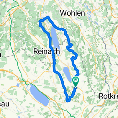
Hochdorf-Küssnacht-Vitznau-Ägerisee-Cham-Hochdorf
A cycling route starting in Hochdorf, Canton of Lucerne, Switzerland.
Overview
About this route
- -:--
- Duration
- 110.1 km
- Distance
- 905 m
- Ascent
- 905 m
- Descent
- ---
- Avg. speed
- ---
- Max. altitude

Route quality
Waytypes & surfaces along the route
Waytypes
Busy road
52.9 km
(48 %)
Road
30.1 km
(27 %)
Surfaces
Paved
63.6 km
(58 %)
Unpaved
0.8 km
(<1 %)
Asphalt
59.7 km
(54 %)
Paved (undefined)
2.4 km
(2 %)
Continue with Bikemap
Use, edit, or download this cycling route
You would like to ride Hochdorf-Küssnacht-Vitznau-Ägerisee-Cham-Hochdorf or customize it for your own trip? Here is what you can do with this Bikemap route:
Free features
- Save this route as favorite or in collections
- Copy & plan your own version of this route
- Split it into stages to create a multi-day tour
- Sync your route with Garmin or Wahoo
Premium features
Free trial for 3 days, or one-time payment. More about Bikemap Premium.
- Navigate this route on iOS & Android
- Export a GPX / KML file of this route
- Create your custom printout (try it for free)
- Download this route for offline navigation
Discover more Premium features.
Get Bikemap PremiumFrom our community
Other popular routes starting in Hochdorf
 2016_ch_e8
- Distance
- 79.2 km
- Ascent
- 638 m
- Descent
- 782 m
- Location
- Hochdorf, Canton of Lucerne, Switzerland
 Leicht hügelig um den Sempacher See
- Distance
- 72.9 km
- Ascent
- 910 m
- Descent
- 897 m
- Location
- Hochdorf, Canton of Lucerne, Switzerland
 Auf den Hügeln des Seetals
- Distance
- 62.9 km
- Ascent
- 1,078 m
- Descent
- 1,077 m
- Location
- Hochdorf, Canton of Lucerne, Switzerland
 Leicht hügelig um den Sempacher See
- Distance
- 73 km
- Ascent
- 796 m
- Descent
- 797 m
- Location
- Hochdorf, Canton of Lucerne, Switzerland
 Über den Lindenberg
- Distance
- 37.7 km
- Ascent
- 607 m
- Descent
- 612 m
- Location
- Hochdorf, Canton of Lucerne, Switzerland
 2025-05-31 Tour
- Distance
- 31.9 km
- Ascent
- 346 m
- Descent
- 347 m
- Location
- Hochdorf, Canton of Lucerne, Switzerland
 2025-05-31_Planung1
- Distance
- 31.4 km
- Ascent
- 356 m
- Descent
- 357 m
- Location
- Hochdorf, Canton of Lucerne, Switzerland
 3-Seen Runde umgedreht
- Distance
- 78.1 km
- Ascent
- 852 m
- Descent
- 852 m
- Location
- Hochdorf, Canton of Lucerne, Switzerland
Open it in the app