
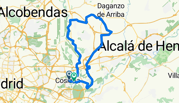
Coslada - Ajalvir - Paracuellos - Coslada
A cycling route starting in Coslada, Madrid, Spain.
Overview
About this route
50 kilometers of MTB through the Corredor del Henares.
2/5 climbing 1/5 descending 2/5 on flat terrain
- -:--
- Duration
- 47.8 km
- Distance
- 270 m
- Ascent
- 274 m
- Descent
- ---
- Avg. speed
- ---
- Max. altitude

Route highlights
Points of interest along the route
Point of interest after 0 km
Salimos desde la tienda de bicicletas "Ciclos Volata" en dirección al Parque de los Chopos de San Fernando de Henares.
Point of interest after 5.4 km
Una vez cruzamos el Jarama, giramos al a izquierda y seguimos paralelos a la M45.
Point of interest after 8.6 km
Túnel bajo la M206. Seguimos de frente.
Point of interest after 9.3 km
Tunel a nuestra derecha. Al cruzarlo, seguimos por nuestra izquierda.
Point of interest after 10.2 km
Zona con polígono industrial. Seguimos de frente y, las dos siguientes rotondas, a la izquierda.
Point of interest after 11.9 km
Pasamos por encima de la A2 a través de una pasarela. Después, por el margen izquierdo de la M115 hasta que se pueda.
Point of interest after 12.3 km
Rotonda. Nos incorporamos a la circulación. En la siguiente rotonda nos saldremos por una vía pecuaria que se abre a nuestra derecha.
Point of interest after 13.5 km
Vía pecuaria. Seguimos paralelos a la M115, pero ahora por su izquierda.
Point of interest after 16.8 km
Rotonda. Nos incorporamos a la circulación en dirección Ajalvir.
Point of interest after 18.5 km
Dos rotondas después, una nueva vía pecuaria se abre a nuestra derecha. Abandonamos el asfalto y seguimos paralelos al Aeropuerto de Torrejón de Ardoz.
Point of interest after 20.2 km
En el momento en que aparezca un puente sobre la Radial 2 lo cruzamos.
Point of interest after 21.1 km
Una vez superamos el puente, el camino hace una U y asciende en un corto tramo. Si tomásemos la pista ancha que aparece a nuestra izquierda, terminaríamos en Daganzo.
Point of interest after 25.5 km
A la derecha del cementerio asciende un camino. Lo tomamos.
Point of interest after 26.4 km
Cruce de caminos. Seguimos por nuestra izquierda, por la pista que nos lleva a un depósito que se ve al fondo.
Point of interest after 28.1 km
Finca con casa de tejado verde. Giramos a nuestra izquierda por una pista que nos llevará a un puente que cruzará la M50.
Point of interest after 29.1 km
Una vez cruzamos la M50, sale una pista de frente y a nuestra derecha. Descenso rápido hacia la Urbanización Peña del Cuervo.
Point of interest after 31.7 km
Una vez entramos en la Urbanización, descedemos hasta la entrada.
Point of interest after 32.4 km
Rotonda de acceso a la Urbanización. Seguimos de frente, por una pista de tierra.
Point of interest after 32.9 km
Giraremos a nuestra derecha en cuanto podamos, por un camino que aparece con alguna que otra indicación.
Point of interest after 33.6 km
Una vez pasamos una zona sombría, tomamos una senda que aparece a nuestra derecha y que nos llevará a otro sendero paralelo al río Jarama.
Point of interest after 35.2 km
Pasarela metálica. Cruzamos el río y seguimos por la otra margen.
Point of interest after 43.8 km
Al final de la pista, una carretera nos conduce hacia la A2. Antes de llegar a ella, tomaremos una calle que desciende por nuestra derecha para, más adelante, subir por una rampa hacia un puente sobre la A2. Solo resta pasar bajo las vías del tren y llegar de nuevo a Coslada
Continue with Bikemap
Use, edit, or download this cycling route
You would like to ride Coslada - Ajalvir - Paracuellos - Coslada or customize it for your own trip? Here is what you can do with this Bikemap route:
Free features
- Save this route as favorite or in collections
- Copy & plan your own version of this route
- Sync your route with Garmin or Wahoo
Premium features
Free trial for 3 days, or one-time payment. More about Bikemap Premium.
- Navigate this route on iOS & Android
- Export a GPX / KML file of this route
- Create your custom printout (try it for free)
- Download this route for offline navigation
Discover more Premium features.
Get Bikemap PremiumFrom our community
Other popular routes starting in Coslada
 Coslada - Velilla de San Antonio - Loeches - Torres de la Alameda - Torrejón de Ardoz - Coslada
- Distance
- 50.6 km
- Ascent
- 303 m
- Descent
- 310 m
- Location
- Coslada, Madrid, Spain
 Coslada - Paracuellos del Jarama - Dehesa de Cobeña - Daganzo de Arriba - Coslada
- Distance
- 57.2 km
- Ascent
- 340 m
- Descent
- 345 m
- Location
- Coslada, Madrid, Spain
 Coslada - Dehesa Boyal - Coslada
- Distance
- 59.2 km
- Ascent
- 224 m
- Descent
- 227 m
- Location
- Coslada, Madrid, Spain
 Coslada - Villalbilla
- Distance
- 30.6 km
- Ascent
- 219 m
- Descent
- 114 m
- Location
- Coslada, Madrid, Spain
 Coslada - Velilla de San Antonio - Campo Real - Arganda del Rey -Velilla de San Antonio - Coslada
- Distance
- 55.4 km
- Ascent
- 311 m
- Descent
- 311 m
- Location
- Coslada, Madrid, Spain
 33 evitando cortes 20250907 Meco 108 km
- Distance
- 107.9 km
- Ascent
- 3,329 m
- Descent
- 3,339 m
- Location
- Coslada, Madrid, Spain
 39 bis 20251019 Nuevo Baztán 90 km
- Distance
- 89.7 km
- Ascent
- 6,536 m
- Descent
- 6,546 m
- Location
- Coslada, Madrid, Spain
 Coslada - Valverde de Alcalá - Los Hueros - Coslada
- Distance
- 64.1 km
- Ascent
- 436 m
- Descent
- 437 m
- Location
- Coslada, Madrid, Spain
Open it in the app