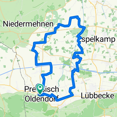
Stemmwede (Runde von Levern) 27km
A cycling route starting in Preußisch Oldendorf, North Rhine-Westphalia, Germany.
Overview
About this route
Rundtour in Stemmwede
- -:--
- Duration
- 26.6 km
- Distance
- 52 m
- Ascent
- 51 m
- Descent
- ---
- Avg. speed
- ---
- Avg. speed
Route quality
Waytypes & surfaces along the route
Waytypes
Quiet road
18.3 km
(69 %)
Busy road
4.1 km
(15 %)
Surfaces
Paved
18.7 km
(70 %)
Paved (undefined)
13.4 km
(50 %)
Asphalt
5.3 km
(20 %)
Undefined
7.9 km
(30 %)
Route highlights
Points of interest along the route
Point of interest after 8.3 km
Naturgarten
Point of interest after 10.1 km
Bauerncafe Wehebrink
Point of interest after 23.1 km
Diestel
Continue with Bikemap
Use, edit, or download this cycling route
You would like to ride Stemmwede (Runde von Levern) 27km or customize it for your own trip? Here is what you can do with this Bikemap route:
Free features
- Save this route as favorite or in collections
- Copy & plan your own version of this route
- Sync your route with Garmin or Wahoo
Premium features
Free trial for 3 days, or one-time payment. More about Bikemap Premium.
- Navigate this route on iOS & Android
- Export a GPX / KML file of this route
- Create your custom printout (try it for free)
- Download this route for offline navigation
Discover more Premium features.
Get Bikemap PremiumFrom our community
Other popular routes starting in Preußisch Oldendorf
- Stellp.Hollenmüle/Dümmersee u.zurück 54km
- Distance
- 53.9 km
- Ascent
- 117 m
- Descent
- 117 m
- Location
- Preußisch Oldendorf, North Rhine-Westphalia, Germany
- Guten Morgen Runde
- Distance
- 23.7 km
- Ascent
- 85 m
- Descent
- 85 m
- Location
- Preußisch Oldendorf, North Rhine-Westphalia, Germany
- Levern-Stemwede-Rahden-Levern
- Distance
- 55.2 km
- Ascent
- 62 m
- Descent
- 64 m
- Location
- Preußisch Oldendorf, North Rhine-Westphalia, Germany
- Engershausen-Vehlage-Espelkamp-Engershausen
- Distance
- 37.4 km
- Ascent
- 63 m
- Descent
- 64 m
- Location
- Preußisch Oldendorf, North Rhine-Westphalia, Germany
- Limberg bis Bad Essen
- Distance
- 20.5 km
- Ascent
- 263 m
- Descent
- 372 m
- Location
- Preußisch Oldendorf, North Rhine-Westphalia, Germany
- Desteler Runde
- Distance
- 16.2 km
- Ascent
- 34 m
- Descent
- 36 m
- Location
- Preußisch Oldendorf, North Rhine-Westphalia, Germany
- Levern-Hüde-Levern
- Distance
- 49.6 km
- Ascent
- 90 m
- Descent
- 90 m
- Location
- Preußisch Oldendorf, North Rhine-Westphalia, Germany
- Alte Rittersitze und Herrenhäuser im früheren Amt Alswede
- Distance
- 29.4 km
- Ascent
- 38 m
- Descent
- 38 m
- Location
- Preußisch Oldendorf, North Rhine-Westphalia, Germany
Open it in the app