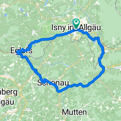
Montagsrunde_06062011_02
A cycling route starting in Isny im Allgäu, Baden-Württemberg, Germany.
Overview
About this route
Überwiegend auf gut befestigten Waldwegen
mit Kindern
für Tourenräder und Mountainbike gut zu fahren
- -:--
- Duration
- 20.3 km
- Distance
- 200 m
- Ascent
- 197 m
- Descent
- ---
- Avg. speed
- ---
- Max. altitude
Continue with Bikemap
Use, edit, or download this cycling route
You would like to ride Montagsrunde_06062011_02 or customize it for your own trip? Here is what you can do with this Bikemap route:
Free features
- Save this route as favorite or in collections
- Copy & plan your own version of this route
- Sync your route with Garmin or Wahoo
Premium features
Free trial for 3 days, or one-time payment. More about Bikemap Premium.
- Navigate this route on iOS & Android
- Export a GPX / KML file of this route
- Create your custom printout (try it for free)
- Download this route for offline navigation
Discover more Premium features.
Get Bikemap PremiumFrom our community
Other popular routes starting in Isny im Allgäu
- Alpen Comer See
- Distance
- 924.8 km
- Ascent
- 6,005 m
- Descent
- 6,012 m
- Location
- Isny im Allgäu, Baden-Württemberg, Germany
- Isny - Allgäuer Käsestraße - HeumilchKäse Runde - Isny - Allgäuer Käsestraße - HeumilchKäse Runde
- Distance
- 31.1 km
- Ascent
- 504 m
- Descent
- 503 m
- Location
- Isny im Allgäu, Baden-Württemberg, Germany
- Schwarzer-Grat 1118 m (höchster Berg von Württemberg)
- Distance
- 11.9 km
- Ascent
- 401 m
- Descent
- 403 m
- Location
- Isny im Allgäu, Baden-Württemberg, Germany
- Schwarzer Grat-Kreuzthal_2021-09-23
- Distance
- 65.9 km
- Ascent
- 1,241 m
- Descent
- 1,325 m
- Location
- Isny im Allgäu, Baden-Württemberg, Germany
- Montagsrunde_06062011_02
- Distance
- 20.3 km
- Ascent
- 200 m
- Descent
- 197 m
- Location
- Isny im Allgäu, Baden-Württemberg, Germany
- AR - Sport Haschko Mittelstrecke 120
- Distance
- 119.1 km
- Ascent
- 1,231 m
- Descent
- 1,227 m
- Location
- Isny im Allgäu, Baden-Württemberg, Germany
- Unterhalb der Kugel
- Distance
- 26.2 km
- Ascent
- 617 m
- Descent
- 614 m
- Location
- Isny im Allgäu, Baden-Württemberg, Germany
- Argenbühl - Isny - Rundfahrt
- Distance
- 37.8 km
- Ascent
- 336 m
- Descent
- 343 m
- Location
- Isny im Allgäu, Baden-Württemberg, Germany
Open it in the app