

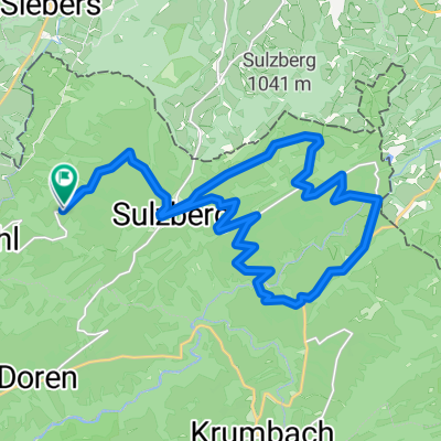
2011_6_Vorarlberg-Tirol-Allgäu-Runde (BAFGOR)_Sulzberg - Lindau
A cycling route starting in Sulzberg, Vorarlberg, Austria.
Overview
About this route
BAFGOR
B = Bielerhöhe A = Arlberg Pass F = Flexen Pass G = Gaicht Pass O = Oberjoch Pass R = Rohrmoos Saddle
- -:--
- Duration
- 54 km
- Distance
- 680 m
- Ascent
- 1,305 m
- Descent
- ---
- Avg. speed
- ---
- Max. altitude

Route quality
Waytypes & surfaces along the route
Waytypes
Quiet road
20.5 km
(38 %)
Road
18.9 km
(35 %)
Surfaces
Paved
50.2 km
(93 %)
Unpaved
1.6 km
(3 %)
Asphalt
50.2 km
(93 %)
Ground
1.1 km
(2 %)
Continue with Bikemap
Use, edit, or download this cycling route
You would like to ride 2011_6_Vorarlberg-Tirol-Allgäu-Runde (BAFGOR)_Sulzberg - Lindau or customize it for your own trip? Here is what you can do with this Bikemap route:
Free features
- Save this route as favorite or in collections
- Copy & plan your own version of this route
- Sync your route with Garmin or Wahoo
Premium features
Free trial for 3 days, or one-time payment. More about Bikemap Premium.
- Navigate this route on iOS & Android
- Export a GPX / KML file of this route
- Create your custom printout (try it for free)
- Download this route for offline navigation
Discover more Premium features.
Get Bikemap PremiumFrom our community
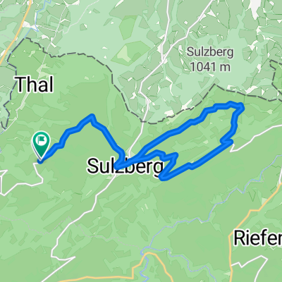
Other popular routes starting in Sulzberg
 2011_6_Vorarlberg-Tirol-Allgäu-Runde (BAFGOR)_Sulzberg - Lindau
- Distance
- 54 km
- Ascent
- 680 m
- Descent
- 1,305 m
- Location
- Sulzberg, Vorarlberg, Austria
 Sulzberg-Lecknertal-Immenstadt
- Distance
- 77.2 km
- Ascent
- 1,273 m
- Descent
- 1,272 m
- Location
- Sulzberg, Vorarlberg, Austria
 Sulzberg | Rundtour Sonnseite über Riefensberg
- Distance
- 23.9 km
- Ascent
- 871 m
- Descent
- 867 m
- Location
- Sulzberg, Vorarlberg, Austria
 Sulzberg | Radtour Sonnseite
- Distance
- 16 km
- Ascent
- 552 m
- Descent
- 546 m
- Location
- Sulzberg, Vorarlberg, Austria
 bregenzerwald passathon
- Distance
- 59.4 km
- Ascent
- 1,028 m
- Descent
- 1,360 m
- Location
- Sulzberg, Vorarlberg, Austria
 Sulzberg-Ulm
- Distance
- 161.4 km
- Ascent
- 1,569 m
- Descent
- 2,085 m
- Location
- Sulzberg, Vorarlberg, Austria
 Bregenz Münich 200 KM
- Distance
- 203.7 km
- Ascent
- 1,007 m
- Descent
- 1,067 m
- Location
- Sulzberg, Vorarlberg, Austria
 Um den Pfänder
- Distance
- 35.3 km
- Ascent
- 823 m
- Descent
- 788 m
- Location
- Sulzberg, Vorarlberg, Austria
Open it in the app