

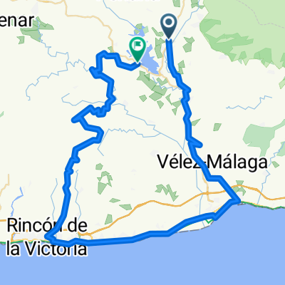
MÁLAGA - Rincón de la Victoria - Moclinejo - Torre del Mar - Rincón
A cycling route starting in Viñuela, Andalusia, Spain.
Overview
About this route
Can you leave the car in Moclinejo and have Tere stay in Rincón at the end?
- -:--
- Duration
- 52.5 km
- Distance
- 967 m
- Ascent
- 964 m
- Descent
- ---
- Avg. speed
- 604 m
- Max. altitude

Route quality
Waytypes & surfaces along the route
Waytypes
Road
23.1 km
(44 %)
Quiet road
14.7 km
(28 %)
Surfaces
Paved
13.6 km
(26 %)
Unpaved
5.2 km
(10 %)
Asphalt
11 km
(21 %)
Paved (undefined)
2.6 km
(5 %)
Continue with Bikemap
Use, edit, or download this cycling route
You would like to ride MÁLAGA - Rincón de la Victoria - Moclinejo - Torre del Mar - Rincón or customize it for your own trip? Here is what you can do with this Bikemap route:
Free features
- Save this route as favorite or in collections
- Copy & plan your own version of this route
- Sync your route with Garmin or Wahoo
Premium features
Free trial for 3 days, or one-time payment. More about Bikemap Premium.
- Navigate this route on iOS & Android
- Export a GPX / KML file of this route
- Create your custom printout (try it for free)
- Download this route for offline navigation
Discover more Premium features.
Get Bikemap PremiumFrom our community
Other popular routes starting in Viñuela
 Xterra Viñuela 2014
- Distance
- 44.4 km
- Ascent
- 1,810 m
- Descent
- 1,812 m
- Location
- Viñuela, Andalusia, Spain
 La Viñuela
- Distance
- 30.9 km
- Ascent
- 551 m
- Descent
- 406 m
- Location
- Viñuela, Andalusia, Spain
 MÁLAGA - Rincón de la Victoria - Moclinejo - Torre del Mar - Rincón
- Distance
- 52.5 km
- Ascent
- 967 m
- Descent
- 964 m
- Location
- Viñuela, Andalusia, Spain
 Vinuela 40 km loop
- Distance
- 42.5 km
- Ascent
- 607 m
- Descent
- 586 m
- Location
- Viñuela, Andalusia, Spain
 day 3
day 3- Distance
- 87 km
- Ascent
- 1,141 m
- Descent
- 1,118 m
- Location
- Viñuela, Andalusia, Spain
 Anda20_52km_920hm_Vinuela
- Distance
- 52 km
- Ascent
- 879 m
- Descent
- 879 m
- Location
- Viñuela, Andalusia, Spain
 Desafío - La Viñuela
- Distance
- 7.2 km
- Ascent
- 115 m
- Descent
- 121 m
- Location
- Viñuela, Andalusia, Spain
 Torre del Mar-Periana por via Tren-Vtas-Alcaucin
- Distance
- 63.9 km
- Ascent
- 884 m
- Descent
- 1,114 m
- Location
- Viñuela, Andalusia, Spain
Open it in the app