UFSCar até Cristinho em São Carlos. Desvia 800m do Caminho da Fé.
A cycling route starting in São Carlos, São Paulo, Brazil.
Overview
About this route
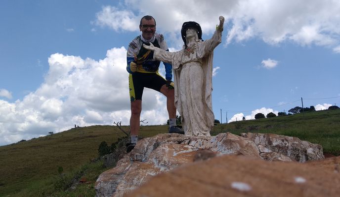
Trilha diferente do que você já encontrou. Passa pelo Horto, Fagá, Tangará, pega fazendas (2 porteiras que tem que pular e 2 abertas. Sai já no CF e anda 100 metros em sentido contrário, para pegar a estrada da invernada, ao lado da Siltomac. Vai sair no Caminho da Fé, 2km após a Aparecidinha (Santuário da Babilonia). Mais pra frente, sai do CF e entra a direita na Estrada Jurandir Bianco. A apenas 800 metro do CF, está a Serra do Cristinho e seu Cristinho dominando o vale. Depois da estatua do Cristinho, tem uma descida brava que pouquissímois descem e consegiuen voltar sem empurrar a bike.
- -:--
- Duration
- 22.7 km
- Distance
- 342 m
- Ascent
- 281 m
- Descent
- ---
- Avg. speed
- 985 m
- Max. altitude
Route photos
Route quality
Waytypes & surfaces along the route
Waytypes
Road
15 km
(66 %)
Quiet road
6.4 km
(28 %)
Surfaces
Paved
4.3 km
(19 %)
Unpaved
14.8 km
(65 %)
Unpaved (undefined)
14.5 km
(64 %)
Asphalt
3.6 km
(16 %)
Continue with Bikemap
Use, edit, or download this cycling route
You would like to ride UFSCar até Cristinho em São Carlos. Desvia 800m do Caminho da Fé. or customize it for your own trip? Here is what you can do with this Bikemap route:
Free features
- Save this route as favorite or in collections
- Copy & plan your own version of this route
- Sync your route with Garmin or Wahoo
Premium features
Free trial for 3 days, or one-time payment. More about Bikemap Premium.
- Navigate this route on iOS & Android
- Export a GPX / KML file of this route
- Create your custom printout (try it for free)
- Download this route for offline navigation
Discover more Premium features.
Get Bikemap PremiumFrom our community
Other popular routes starting in São Carlos
 Caminho da fé
- Distance
- 510.8 km
- Ascent
- 4,065 m
- Descent
- 4,356 m
- Location
- São Carlos, São Paulo, Brazil
 UFSCar - Cachoeira da Alegria
- Distance
- 16.2 km
- Ascent
- 103 m
- Descent
- 299 m
- Location
- São Carlos, São Paulo, Brazil
 de volta!
- Distance
- 4.1 km
- Ascent
- 32 m
- Descent
- 33 m
- Location
- São Carlos, São Paulo, Brazil
 cachoeira pão com linguiça
- Distance
- 54.2 km
- Ascent
- 114 m
- Descent
- 158 m
- Location
- São Carlos, São Paulo, Brazil
 Porcos
- Distance
- 36.2 km
- Ascent
- 430 m
- Descent
- 434 m
- Location
- São Carlos, São Paulo, Brazil
 UFSCar até Cristinho em São Carlos. Desvia 800m do Caminho da Fé.
- Distance
- 22.7 km
- Ascent
- 342 m
- Descent
- 281 m
- Location
- São Carlos, São Paulo, Brazil
 Educativa - IFSP
- Distance
- 12.1 km
- Ascent
- 179 m
- Descent
- 125 m
- Location
- São Carlos, São Paulo, Brazil
 De Avenida Pedro Neo, 3124-3178 a Avenida Pedro Neo, 3124-3178
- Distance
- 19.9 km
- Ascent
- 221 m
- Descent
- 221 m
- Location
- São Carlos, São Paulo, Brazil
Open it in the app


